IMAGES TAKEN NEAR TO
Heathway, DAGENHAM, RM10 8QS
Introduction
This page details the photographs taken nearby to Heathway, RM10 8QS by members of the Geograph project.
The Geograph project started in 2005 with the aim of publishing, organising and preserving representative images for every square kilometre of Great Britain, Ireland and the Isle of Man.

There are currently over 7.5m images from over14,400 individuals and you can help contribute to the project by visiting https://www.geograph.org.uk
Image Map
Images are licensed for reuse under creativecommons.org/licenses/by-sa/2.0
Notes
- Clicking on the map will re-center to the selected point.
- The higher the marker number, the further away the image location is from the centre of the postcode.
Image Listing (62 Images Found)
Images are licensed for reuse under creativecommons.org/licenses/by-sa/2.0
Image
Details
Distance
1
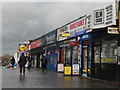
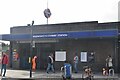
Heathway, Dagenham
These shops are located on the railway bridge, and the entrance to Dagenham Heathway station (a stop on the Underground's District Line) is immediately opposite. This stretch of road is effectively Dagenham's town centre, developed in the 1930s to serve the new housing estates surrounding it; of course the businesses here now - a minicab firm, a mobile phone repairer, a gaming centre and an estate agent - are very different from those that would have been here originally.
Image: © Stephen McKay
Taken: 13 Feb 2020
0.01 miles
2
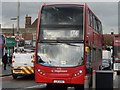
174 to Dagenham Marsh Way
A bus on route 174 makes its way along Heathway, close to Dagenham Heathway station, on a journey from Harold Hill.
Image: © Stephen McKay
Taken: 13 Feb 2020
0.01 miles
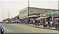
3
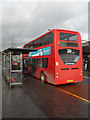
Heathway, Dagenham
A bus on route 174 heading for Romford and Harold Hill waits at stop 'B' close to Dagenham Heathway Underground station.
Image: © Stephen McKay
Taken: 13 Feb 2020
0.02 miles
4
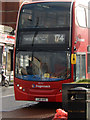
174 to Harold Hill
A Stagecoach vehicle on Transport for London's route 174 to Romford and Harold Hill pulls up at the stop close to Dagenham Heathway station.
Image: © Stephen McKay
Taken: 13 Feb 2020
0.02 miles
7
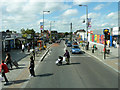
Heathway, Dagenham at Dagenham Heathway
At the pedestrian crossing on the railway bridge, with at least some of the folk who crossed the road making for the station entrance.
Image: © Robin Webster
Taken: 25 Jun 2011
0.02 miles
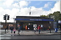
10
Dagenham Heathway station, exterior
View southward on Heathway: London right, Upminster left. Opened as 'Heathway' by the LMSR 12/9/32 on its Fenchurch Street - Shoeburyness direct line via Becontree and on the London Underground District line to Upminster, it was renamed 'Dagenham Heathway on 1/5/49. Since 12/6/61 it has been served only by District line trains.
Image: © Ben Brooksbank
Taken: 25 May 1991
0.02 miles