IMAGES TAKEN NEAR TO
Heathway, DAGENHAM, RM10 8PE
Introduction
This page details the photographs taken nearby to Heathway, RM10 8PE by members of the Geograph project.
The Geograph project started in 2005 with the aim of publishing, organising and preserving representative images for every square kilometre of Great Britain, Ireland and the Isle of Man.

There are currently over 7.5m images from over14,400 individuals and you can help contribute to the project by visiting https://www.geograph.org.uk
Image Map
Images are licensed for reuse under creativecommons.org/licenses/by-sa/2.0
Notes
- Clicking on the map will re-center to the selected point.
- The higher the marker number, the further away the image location is from the centre of the postcode.
Image Listing (60 Images Found)
Images are licensed for reuse under creativecommons.org/licenses/by-sa/2.0
Image
Details
Distance
5
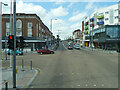
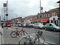
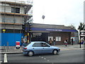
A1240 Heathway, Dagenham
Looking towards the rise over the railway at Dagenham Heathway station.
Image: © Robin Webster
Taken: 25 Jun 2011
0.03 miles
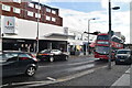
6
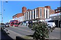
NEW
Dagenham Heathway
The main road north-south through here, also known as A1240. Quite short for an A road at under 3 kms, but it has a brief mention here https://www.sabre-roads.org.uk/wiki/index.php?title=A1240
Image: © Des Blenkinsopp
Taken: 3 Mar 2025
0.03 miles
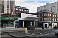
7
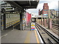
Dagenham Heathway Underground station, Greater London
Opened in 1932 by the London Midland & Scottish Railway on the line from London to Upminster, this station transferred from British Rail to London Transport in 1969.
View east at entrance. Like 55% of the London Underground network, this part is actually overground. The pillars to the right used to support a large building covering the tracks, recently removed.
Image: © Nigel Thompson
Taken: 24 Sep 2015
0.04 miles
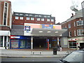
10
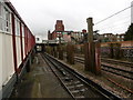
Looking east from Dagenham Heathway Underground station
The London, Tilbury & Southend Railway opened its line from Forest Gate via Barking and Dagenham Dock to Tilbury in 1854. In 1858 the company opened a cut off between Bow and Barking.
What is now the C2C line was opened in 1885 by the London, Tilbury & Southend Railway between Barking and Upminster, and a station was opened at Dagenham (East) the same year. No further stations opened on the line until Gale Street Halt (now Becontree) in 1926, followed by Hornchurch, Heathway (later renamed Dagenham Heathway from 1st May 1949) and Upney on 12th September 1932. On the same date as these stations opened in 1932, the District line was extended over new tracks alongside the existing line between Barking and Upminster. The present C2C line therefore dates from 1885 and the present District line from 1932.
This view from the end of the up platform looks along the up District line with the two C2C lines to the right. The ramp up to the ticket hall is on the left and the bridge carrying Heathway over the lines is straight ahead. Dagenham East is the next station in this direction.
Image: © Marathon
Taken: 9 Mar 2016
0.04 miles