IMAGES TAKEN NEAR TO
Auriel Avenue, DAGENHAM, RM10 8BS
Introduction
This page details the photographs taken nearby to Auriel Avenue, RM10 8BS by members of the Geograph project.
The Geograph project started in 2005 with the aim of publishing, organising and preserving representative images for every square kilometre of Great Britain, Ireland and the Isle of Man.

There are currently over 7.5m images from over14,400 individuals and you can help contribute to the project by visiting https://www.geograph.org.uk
Image Map
Images are licensed for reuse under creativecommons.org/licenses/by-sa/2.0
Notes
- Clicking on the map will re-center to the selected point.
- The higher the marker number, the further away the image location is from the centre of the postcode.
Image Listing (8 Images Found)
Images are licensed for reuse under creativecommons.org/licenses/by-sa/2.0
Image
Details
Distance
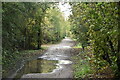
1
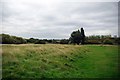
Beam Valley Country Park
This is not the sort of scene you expect to see in urban Dagenham. However this is part of the 182 acre (74 ha) Beam Valley Country Park. . http://www.barking-dagenham.gov.uk/8-leisure-envir/park-country/beam-valley.html
Image: © Glyn Baker
Taken: 3 Oct 2010
0.20 miles
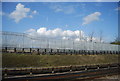
6
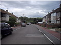
Western Avenue, Dagenham
Looking toward Beam Valley Country Park
Image: © PAUL FARMER
Taken: 13 May 2011
0.24 miles
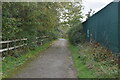
7
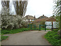
Beam Valley Country Park - way out
To the road behind houses on Western Avenue.
Image: © Robin Webster
Taken: 2 Apr 2011
0.24 miles
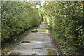
8
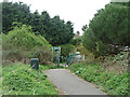
Beam Valley Country Park - way out
To Western Avenue, also the start of footpath 27 to Eastbrookend Country Park.
Image: © Robin Webster
Taken: 2 Apr 2011
0.25 miles