IMAGES TAKEN NEAR TO
Shafter Road, DAGENHAM, RM10 8AB
Introduction
This page details the photographs taken nearby to Shafter Road, RM10 8AB by members of the Geograph project.
The Geograph project started in 2005 with the aim of publishing, organising and preserving representative images for every square kilometre of Great Britain, Ireland and the Isle of Man.

There are currently over 7.5m images from over14,400 individuals and you can help contribute to the project by visiting https://www.geograph.org.uk
Image Map
Images are licensed for reuse under creativecommons.org/licenses/by-sa/2.0
Notes
- Clicking on the map will re-center to the selected point.
- The higher the marker number, the further away the image location is from the centre of the postcode.
Image Listing (45 Images Found)
Images are licensed for reuse under creativecommons.org/licenses/by-sa/2.0
Image
Details
Distance
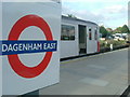
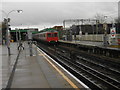
3
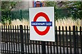
Dagenham East station
The world famous London Transport 'Bullseye' roundel,
this time at Dagenham East station on the District Line.
Most of this station is in the square above,
but about one-third is in this one.
Image: © Phillip Perry
Taken: 1 Aug 2010
0.03 miles
5
Dagenham East Underground Station
Picture of a District Line train just terminated at Dagenham East station, carrying fans to the friendly match between Dagenham & Redbridge and Fulham.
Image: © Phillip Perry
Taken: 17 Jul 2007
0.03 miles
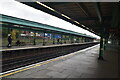
6
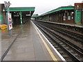
Dagenham East station
The London, Tilbury & Southend Railway opened its line from Forest Gate via Barking and Dagenham Dock to Tilbury in 1854. In 1858 the company opened a cut off between Bow and Barking.
What is now the C2C line was opened in 1885 by the London, Tilbury & Southend Railway between Barking and Upminster, and a station was opened at Dagenham (East) the same year. Little housing development took place around this station until much later on, although some factories were built nearby from about 1900. No further stations opened on the line until Gale Street Halt (now Becontree) in 1926, followed by Hornchurch, Heathway (later renamed Dagenham Heathway from 1st May 1949) and Upney on 12th September 1932. On the same date as these stations opened in 1932, the District line was extended over new tracks alongside the existing line between Barking and Upminster. The present C2C line therefore dates from 1885 and the present District line from 1932.
This view is from the down platform. The next station in this direction is Elm Park.
Image: © Marathon
Taken: 9 Mar 2016
0.03 miles
7
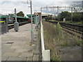
Dagenham East Underground station, Greater London
Opened in 1885 by the London Tilbury & Southend Railway on the line from London to Upminster, this station was rebuilt in 1932 when the platforms to the left were added. The LTS platforms to the right were closed in 1962. The station transferred from British Rail to London Transport in 1969.
View east towards Elm Park and Upminster. Like 55% of the London Underground network, this part is actually overground.
Image: © Nigel Thompson
Taken: 24 Sep 2015
0.03 miles
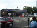
9
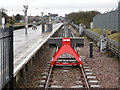
The bay platform at Dagenham East station
The London, Tilbury & Southend Railway opened its line from Forest Gate via Barking and Dagenham Dock to Tilbury in 1854. In 1858 the company opened a cut off between Bow and Barking.
What is now the C2C line was opened in 1885 by the London, Tilbury & Southend Railway between Barking and Upminster, and a station was opened at Dagenham (East) the same year. Little housing development took place around this station until much later on, although some factories were built nearby from about 1900. No further stations opened on the line until Gale Street Halt (now Becontree) in 1926, followed by Hornchurch, Heathway (later renamed Dagenham Heathway from 1st May 1949) and Upney on 12th September 1932. On the same date as these stations opened in 1932, the District line was extended over new tracks alongside the existing line between Barking and Upminster. The present C2C line therefore dates from 1885 and the present District line from 1932.
This view from the end of the down platform looks along the bay where some trains terminate at Dagenham East before running back to Central London. The next station in this direction is Dagenham Heathway.
Image: © Marathon
Taken: 9 Mar 2016
0.04 miles
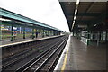
10
Dagenham East Underground station
The London, Tilbury & Southend Railway opened its line from Forest Gate via Barking and Dagenham Dock to Tilbury in 1854. In 1858 the company opened a cut off between Bow and Barking.
What is now the C2C line was opened in 1885 by the London, Tilbury & Southend Railway between Barking and Upminster, and a station was opened at Dagenham (East) the same year. Little housing development took place around this station until much later on, although some factories were built nearby from about 1900. No further stations opened on the line until Gale Street Halt (now Becontree) in 1926, followed by Hornchurch, Heathway (later renamed Dagenham Heathway from 1st May 1949) and Upney on 12th September 1932. On the same date as these stations opened in 1932, the District line was extended over new tracks alongside the existing line between Barking and Upminster. The present C2C line therefore dates from 1885 and the present District line from 1932.
This view is from the down platform. A train bound for Richmond is about to leave.
Image: © Marathon
Taken: 9 Mar 2016
0.04 miles