IMAGES TAKEN NEAR TO
Foxlands Crescent, DAGENHAM, RM10 7TB
Introduction
This page details the photographs taken nearby to Foxlands Crescent, RM10 7TB by members of the Geograph project.
The Geograph project started in 2005 with the aim of publishing, organising and preserving representative images for every square kilometre of Great Britain, Ireland and the Isle of Man.

There are currently over 7.5m images from over14,400 individuals and you can help contribute to the project by visiting https://www.geograph.org.uk
Image Map
Images are licensed for reuse under creativecommons.org/licenses/by-sa/2.0
Notes
- Clicking on the map will re-center to the selected point.
- The higher the marker number, the further away the image location is from the centre of the postcode.
Image Listing (5 Images Found)
Images are licensed for reuse under creativecommons.org/licenses/by-sa/2.0
Image
Details
Distance
1
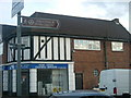
Victoria Road, Dagenham
Victoria Road, Dagenham home to Dagenham & Redbridge FC.
Image: © Phillip Perry
Taken: 17 Jul 2007
0.12 miles
3
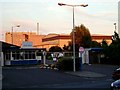
Sanofi-Aventis
The Sanofi-Aventis pharmaceutical works in Dagenham. S-A is Europe’s largest pharmaceutical manufacturer and the worlds number three. However to me the Dagenham plant will forever be May & Baker’s
Image: © Glyn Baker
Taken: 7 Sep 2005
0.19 miles
5

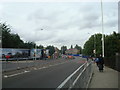
Dagenham & Redbridge FC
Half-time warm-up in a friendly match between Dagenham & Redbridge
and Fulham FC. That's the Fulham side and they won 1-0.
Image: © Phillip Perry
Taken: 17 Jul 2007
0.23 miles