IMAGES TAKEN NEAR TO
Marston Avenue, DAGENHAM, RM10 7LD
Introduction
This page details the photographs taken nearby to Marston Avenue, RM10 7LD by members of the Geograph project.
The Geograph project started in 2005 with the aim of publishing, organising and preserving representative images for every square kilometre of Great Britain, Ireland and the Isle of Man.

There are currently over 7.5m images from over14,400 individuals and you can help contribute to the project by visiting https://www.geograph.org.uk
Image Map
Images are licensed for reuse under creativecommons.org/licenses/by-sa/2.0
Notes
- Clicking on the map will re-center to the selected point.
- The higher the marker number, the further away the image location is from the centre of the postcode.
Image Listing (15 Images Found)
Images are licensed for reuse under creativecommons.org/licenses/by-sa/2.0
Image
Details
Distance
2
Thompson Road, Dagenham
The tree is on a tiny green at the corner with Heathway.
Image: © Robin Webster
Taken: 25 Jun 2011
0.15 miles
3
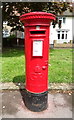
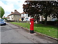
George V postbox on Oxlow Lane, Dagenham
Postbox No. RM10 211.
See Image] for context.
Image: © JThomas
Taken: 11 May 2019
0.20 miles
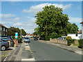
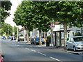
5
Oxlow Lane, Dagenham
Showing position of Postbox No. RM10 211.
See Image] for postbox.
Image: © JThomas
Taken: 11 May 2019
0.21 miles
6
Heathway bus stop (T) on Oxlow Lane
Served by route 174 towards Dagenham.
Image: © Robin Webster
Taken: 25 Jun 2011
0.21 miles