IMAGES TAKEN NEAR TO
Rainham Road North, DAGENHAM, RM10 7ES
Introduction
This page details the photographs taken nearby to Rainham Road North, RM10 7ES by members of the Geograph project.
The Geograph project started in 2005 with the aim of publishing, organising and preserving representative images for every square kilometre of Great Britain, Ireland and the Isle of Man.

There are currently over 7.5m images from over14,400 individuals and you can help contribute to the project by visiting https://www.geograph.org.uk
Image Map
Images are licensed for reuse under creativecommons.org/licenses/by-sa/2.0
Notes
- Clicking on the map will re-center to the selected point.
- The higher the marker number, the further away the image location is from the centre of the postcode.
Image Listing (18 Images Found)
Images are licensed for reuse under creativecommons.org/licenses/by-sa/2.0
Image
Details
Distance
1
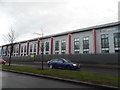
Dagenham Business Centre on Rainham Road
Image: © David Howard
Taken: 5 Mar 2017
0.06 miles
3
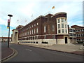
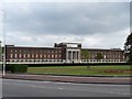
Dagenham Civic Centre
Dagenham Civic Centre is an art deco building dating from the mid-1930s. It is Grade II listed.
In 2017, Coventry University opened its CU London campus here, taking over the original building. It appears that the London Borough of Barking & Dagenham still use offices on the site.
Image: © Malc McDonald
Taken: 28 Aug 2017
0.08 miles
4
Dagenham Civic Offices
An imposing structure
Image: © Glyn Baker
Taken: 16 Aug 2005
0.08 miles
5
Civic Centre, Rainham Road North (1)
Built in 1936-37 by E. Berry Webber with F.C. Lloyd, the Borough Engineer. A striking building which borrows from classical architecture - the portico, its symmetry and use of brick - but which is most definitely also "go-ahead and modern" (Pevsner). Grade II listed.
It serves as the main building of the London Borough of Barking and Dagenham.
Image: © Stephen Richards
Taken: Unknown
0.10 miles
6
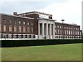
Civic Centre, Rainham Road North (2)
Built in 1936-37 by E. Berry Webber with F.C. Lloyd, the Borough Engineer. A striking building which borrows from classical architecture - the portico, its symmetry and use of brick - but which is most definitely also "go-ahead and modern" (Pevsner). You can't see from the picture, but the panels in the frieze represent Engineering, Local Government and Navigation. Grade II listed.
It serves as the main building of the London Borough of Barking and Dagenham, whose proud boast can be seen above the portico. A wider view can be found here Image
Image: © Stephen Richards
Taken: Unknown
0.10 miles
8
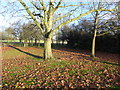
Central Park from Rainham Road North
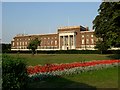
Central Park is situated between Rainham Road North and Rush Green Road, and was laid out behind Dagenham Civic Centre which is a superb example of late-1930s civic architecture. It was built in 1937, as was the fire station beyond it. The grand scale of Central Park reflects the dramatic increase in size of Dagenham between the Wars.
Image: © Marathon
Taken: 14 Dec 2016
0.17 miles
9
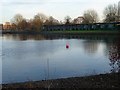
The very strange golf driving range at Wantz Lake
Wantz Lake is a circular artificial lake on the upper reaches of the Wantz Stream. It serves as a balancing reservoir to control flooding further downstream.
It also features in a golf driving range although I would imagine the majority of balls must end up in the lake. A high net on the far side is to stop the golf balls ending up hitting the houses beyond although one would imagine many balls hitting the netting would also end up in the lake! See also http://www.geograph.org.uk/photo/5227019
Image: © Marathon
Taken: 14 Dec 2016
0.22 miles