IMAGES TAKEN NEAR TO
Sandy Lane, OXTED, RH8 9LU
Introduction
This page details the photographs taken nearby to Sandy Lane, RH8 9LU by members of the Geograph project.
The Geograph project started in 2005 with the aim of publishing, organising and preserving representative images for every square kilometre of Great Britain, Ireland and the Isle of Man.

There are currently over 7.5m images from over14,400 individuals and you can help contribute to the project by visiting https://www.geograph.org.uk
Image Map
Images are licensed for reuse under creativecommons.org/licenses/by-sa/2.0
Notes
- Clicking on the map will re-center to the selected point.
- The higher the marker number, the further away the image location is from the centre of the postcode.
Image Listing (62 Images Found)
Images are licensed for reuse under creativecommons.org/licenses/by-sa/2.0
Image
Details
Distance
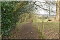
4
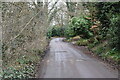
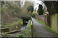
Footpath to The Mount
This path leads from Sandy Lane, past an historic earthwork mound, before reaching Barrow Green Lane.
Image: © David Anstiss
Taken: 16 May 2012
0.10 miles
7
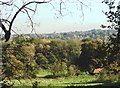
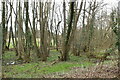
The Bogs, Oxted
The trees in the middle of the picture and the grassy area in the foreground are all in the gridsquare. Although these two areas are probably not strictly speaking a bog despite being so called on maps, they are nevertheless marshy and are where the River Eden has its source. Taken from Sandy Lane.
Image: © David Kemp
Taken: 3 Nov 2006
0.12 miles
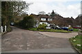
10
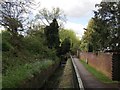
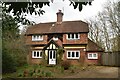
Path beside Townland River, Oxted
This river (looking upstream) flows from Townland Pond to join the River Eden later.
This small section is within a culvert beside a cottage near the A25.
The River Eden starts near Oxted before flowing down to Edenbridge.
A path leads from Church Lane towards Old Oxted High Street.
Image: © David Anstiss
Taken: 16 May 2012
0.14 miles