IMAGES TAKEN NEAR TO
Neb Lane, OXTED, RH8 9JZ
Introduction
This page details the photographs taken nearby to Neb Lane, RH8 9JZ by members of the Geograph project.
The Geograph project started in 2005 with the aim of publishing, organising and preserving representative images for every square kilometre of Great Britain, Ireland and the Isle of Man.

There are currently over 7.5m images from over14,400 individuals and you can help contribute to the project by visiting https://www.geograph.org.uk
Image Map
Images are licensed for reuse under creativecommons.org/licenses/by-sa/2.0
Notes
- Clicking on the map will re-center to the selected point.
- The higher the marker number, the further away the image location is from the centre of the postcode.
Image Listing (9 Images Found)
Images are licensed for reuse under creativecommons.org/licenses/by-sa/2.0
Image
Details
Distance
2
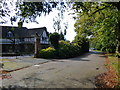
Oxted: Neb Lane
Looking west at the junction with Yew Tree Drive. Don't even think about buying a house along here unless you are seriously rich.
Image: © Dr Neil Clifton
Taken: 7 Oct 2014
0.08 miles

5
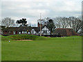
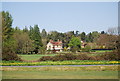
Tandridge Golf Club clubhouse
Seen from the public footpath that crosses the course.
Image: © Robin Webster
Taken: 28 Jan 2011
0.21 miles
7
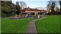
Bushey Croft Children's Playground
Children's playground in Bushey Croft recreation ground, Oxted
Image: © Marvin653
Taken: 2 Dec 2021
0.21 miles
8
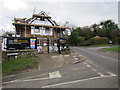
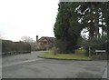
New development under construction by Beadles Lane
At the junction with Springfield.
Image: © Oast House Archive
Taken: 23 Feb 2017
0.22 miles