IMAGES TAKEN NEAR TO
Wilderness Road, OXTED, RH8 9HS
Introduction
This page details the photographs taken nearby to Wilderness Road, RH8 9HS by members of the Geograph project.
The Geograph project started in 2005 with the aim of publishing, organising and preserving representative images for every square kilometre of Great Britain, Ireland and the Isle of Man.

There are currently over 7.5m images from over14,400 individuals and you can help contribute to the project by visiting https://www.geograph.org.uk
Image Map
Images are licensed for reuse under creativecommons.org/licenses/by-sa/2.0
Notes
- Clicking on the map will re-center to the selected point.
- The higher the marker number, the further away the image location is from the centre of the postcode.
Image Listing (37 Images Found)
Images are licensed for reuse under creativecommons.org/licenses/by-sa/2.0
Image
Details
Distance
1
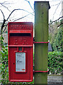
Elizabeth II post-mounted letter box
At the end of Quarry Road. Cast at the bottom of the door is "Carron Company Stirlingshire". This company, who no longer trade as such, did a lot of cast-iron work for the Post Office.
Image: © Robin Webster
Taken: 28 Jan 2011
0.12 miles
3
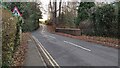
Woodhurst Bridge
Woodhurst Bridge across the River Eden in Woodhurst Lane that was re-constructed in 1994 by Surrey CC
Image: © Marvin653
Taken: 2 Dec 2021
0.15 miles
4
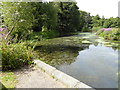
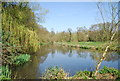
London Countryway in Surrey (31)
At the bottom of Spring Lane is the millpond for Oxted Mill. See also http://www.geograph.org.uk/photo/2417758 from 2011.
Image: © Shazz
Taken: 16 Aug 2017
0.17 miles
5
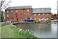
Oxted Mill
Mill pond and mill building now used as business units.
Image: © patrick connolly
Taken: 14 Apr 2010
0.18 miles
6
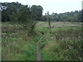
Greensand Way near Oxted
The long distance footpath leads across rough ground by the River Eden at Oxted Mill.
Image: © Chris Heaton
Taken: 14 Sep 2010
0.18 miles
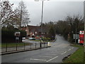
7

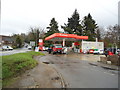
Approaching the Junction between Church Lane and the A25
Image: © Ed of the South
Taken: 29 Aug 2013
0.19 miles
10
London Countryway in Surrey (32)
The Countryway turns north on a path alongside the millpond.
Image: © Shazz
Taken: 16 Aug 2017
0.20 miles