IMAGES TAKEN NEAR TO
Woodhurst Lane, OXTED, RH8 9ED
Introduction
This page details the photographs taken nearby to Woodhurst Lane, RH8 9ED by members of the Geograph project.
The Geograph project started in 2005 with the aim of publishing, organising and preserving representative images for every square kilometre of Great Britain, Ireland and the Isle of Man.

There are currently over 7.5m images from over14,400 individuals and you can help contribute to the project by visiting https://www.geograph.org.uk
Image Map
Images are licensed for reuse under creativecommons.org/licenses/by-sa/2.0
Notes
- Clicking on the map will re-center to the selected point.
- The higher the marker number, the further away the image location is from the centre of the postcode.
Image Listing (22 Images Found)
Images are licensed for reuse under creativecommons.org/licenses/by-sa/2.0
Image
Details
Distance
1
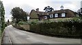
Stonehammer, Woodhurst Lane, Oxted
Image: © Oast House Archive
Taken: 23 Feb 2017
0.02 miles
2
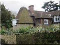
Oast House
An oast or oast-like building.
Image: © Oast House Archive
Taken: 23 Feb 2017
0.02 miles
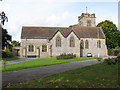
5
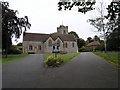
St John the Evangelist, Hurst Green
The church was built in 1913, being extended in 1962 with the construction of St. John's Room. In 1987, the building was substantially damaged by a fire and reconstruction and remodelling work completed in 1991.
Image: © Hywel Williams
Taken: 28 Sep 2005
0.10 miles
6
New extension of St John's church
This new single-storey extension to the church to provide meeting rooms was opened in 2010. For a view of the north side of the church before its construction see Image
Image: © Stephen Craven
Taken: 30 Sep 2010
0.10 miles
7
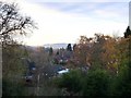
Hurst Green: a view across gardens and rooftops
Seen from the raised station approach. The area must have been entirely rural when the London, Brighton & South Coast Railway reached here in 1884, as it extended its tentacles to Lingfield, Edenbridge and Hever. Even then, it was not until 23 years later - 1907 - that trains condescended to stop. (The station was originally known as 'Hurst Green Halt', making it sound like a request stop). It was only after the place had a station that residential development could go ahead. Hurst Green's permanent parish church was not built until 1912, replacing an earlier structure first provided for the navvies who constructed the railway.
The view is WNW, on a chilly November afternoon. The tower of St John's Church is just visible between two tall cypress trees, just to the right of the centre of the frame. In the distance are the North Downs, beyond the M25.
The history of the railways of these parts is told, in plodding fashion, in Dendy Marshall's book, 'A History of the Southern Railway'.
Image: © Stefan Czapski
Taken: 28 Nov 2010
0.10 miles
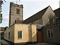
8
St John the Evangelist, Hurst Green
A view of the south side of the church from Church Way. For a similar view see Image
Image: © Stephen Craven
Taken: 30 Sep 2010
0.11 miles
9
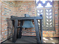
St John's church bell
The single bell in the tower of Saint John the Evangelist, Hurst Green, is only hung for chiming, not full-circle ringing. Its inscription is "church extension 1962 HHP AGS JFB JMB". I guess the initials are those of the Vicar and Churchwardens at the time rather than being abbreviations.
Image: © Stephen Craven
Taken: 13 Sep 2012
0.11 miles
10
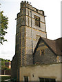
Tower of St John's church
For a view of the other side of the church, see Image
Image: © Stephen Craven
Taken: 30 Sep 2010
0.11 miles