IMAGES TAKEN NEAR TO
Mill Lane, OXTED, RH8 0TJ
Introduction
This page details the photographs taken nearby to Mill Lane, RH8 0TJ by members of the Geograph project.
The Geograph project started in 2005 with the aim of publishing, organising and preserving representative images for every square kilometre of Great Britain, Ireland and the Isle of Man.

There are currently over 7.5m images from over14,400 individuals and you can help contribute to the project by visiting https://www.geograph.org.uk
Image Map
Images are licensed for reuse under creativecommons.org/licenses/by-sa/2.0
Notes
- Clicking on the map will re-center to the selected point.
- The higher the marker number, the further away the image location is from the centre of the postcode.
Image Listing (93 Images Found)
Images are licensed for reuse under creativecommons.org/licenses/by-sa/2.0
Image
Details
Distance
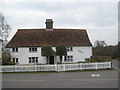
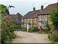
2
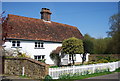
The Mill House, Limpsfield Chart
Grade II listed. http://www.britishlistedbuildings.co.uk/en-287851-the-mill-house-limpsfield
Image: © N Chadwick
Taken: 10 Apr 2011
0.04 miles
4
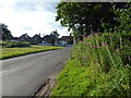
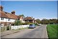
Limpsfield Chart
This is Moorhouse Road about a mile to the south-east of the village of Limpsfield on the edge of the National Trust owned High Chart.
Image: © Marathon
Taken: 1 Jul 2017
0.05 miles
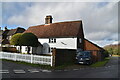
8
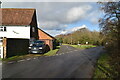
Mill House
On the junction on Tally Road (in front) and Moorhouse Road (on the right).
Image: © David Anstiss
Taken: 13 Mar 2010
0.05 miles
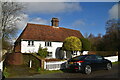
9
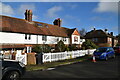
Post Office Row, Limpsfield Chart
The original post office was not where the post box is, but behind the viewpoint closer to the pub here. The cottage with the postbox was later called Post Cottage, but whether it had any official function has not been determined.
Image: © Robin Webster
Taken: 29 Jul 2011
0.05 miles
10

The Mill House, Limpsfield Chart
A grade II listed building, 17th century with later alterations. The windmill was just to the left, the houses are built on the site.
Image: © Robin Webster
Taken: 29 Jul 2011
0.05 miles