IMAGES TAKEN NEAR TO
Caxton Lane, OXTED, RH8 0TD
Introduction
This page details the photographs taken nearby to Caxton Lane, RH8 0TD by members of the Geograph project.
The Geograph project started in 2005 with the aim of publishing, organising and preserving representative images for every square kilometre of Great Britain, Ireland and the Isle of Man.

There are currently over 7.5m images from over14,400 individuals and you can help contribute to the project by visiting https://www.geograph.org.uk
Image Map (Loading...)


Getting Data...Please wait
Leaflet Map data © OpenStreetMap
Images are licensed for reuse under creativecommons.org/licenses/by-sa/2.0
Notes
- Clicking on the map will re-center to the selected point.
- The higher the marker number, the further away the image location is from the centre of the postcode.
Image Listing (22 Images Found)
Images are licensed for reuse under creativecommons.org/licenses/by-sa/2.0
Image
Details
Distance
1
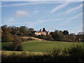
Caxton House, Limpsfield
Large house on the North Downs. Near Chart.
Formerly a Convalescent Home in 1960, according to http://www.francisfrith.com/limpsfield/photos/caxton-convalescent-home-c1960_l48063/#utmcsr=google.co.uk&utmcmd=referral&utmccn=google.co.uk.
Image: © David Anstiss
Taken: 27 Nov 2011
0.09 miles
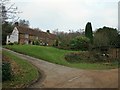
3
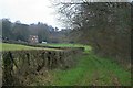
Caxton Lane and Chartlands Farm
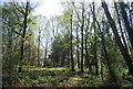
The ridge is threaded with green lanes: within a distance of about one kilometre, there are: Image, bridleway 54, Caxton Lane and Image In older times, they perhaps would have been far from green, with livestock being taken up and down from the common grazing on the wastes of Limpsfield to the inclosed fields below the ridge.
Image: © Hugh Craddock
Taken: 1 Jan 2009
0.16 miles
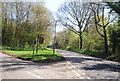
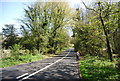
7
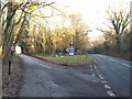
Road junction at Limpsfield Chart
The road to the left leads into the village of Limpsfield Chart. A 30mph speed limit applies through the village.
Image: © Malc McDonald
Taken: 21 Jan 2017
0.21 miles