IMAGES TAKEN NEAR TO
Red Lane, OXTED, RH8 0RS
Introduction
This page details the photographs taken nearby to Red Lane, RH8 0RS by members of the Geograph project.
The Geograph project started in 2005 with the aim of publishing, organising and preserving representative images for every square kilometre of Great Britain, Ireland and the Isle of Man.

There are currently over 7.5m images from over14,400 individuals and you can help contribute to the project by visiting https://www.geograph.org.uk
Image Map
Images are licensed for reuse under creativecommons.org/licenses/by-sa/2.0
Notes
- Clicking on the map will re-center to the selected point.
- The higher the marker number, the further away the image location is from the centre of the postcode.
Image Listing (26 Images Found)
Images are licensed for reuse under creativecommons.org/licenses/by-sa/2.0
Image
Details
Distance
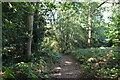
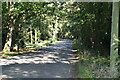
3

Merle Common
A narrow path through the bracken on Merle (Blackbird) Common.
Image: © Glyn Baker
Taken: 12 Feb 2019
0.07 miles
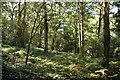
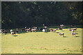
6

Path On Merle Common
By the size of the trees my best guess is regular grazing stopped on Merle Common sometime around WW2.
Image: © Glyn Baker
Taken: 12 Feb 2019
0.09 miles
7
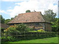
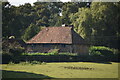
Toby Cottage
Grade II Listed building on Red Lane.
See http://www.britishlistedbuildings.co.uk/en-287844-toby-cottage-limpsfield for more details about the building.
Image: © David Anstiss
Taken: 10 Jul 2011
0.10 miles
9

Pond on Merle Common .
Image in English Blackbird Common. Most of the common is now woodland.
Image: © Glyn Baker
Taken: 12 Feb 2019
0.10 miles