IMAGES TAKEN NEAR TO
Barrow Green Road, OXTED, RH8 0NJ
Introduction
This page details the photographs taken nearby to Barrow Green Road, RH8 0NJ by members of the Geograph project.
The Geograph project started in 2005 with the aim of publishing, organising and preserving representative images for every square kilometre of Great Britain, Ireland and the Isle of Man.

There are currently over 7.5m images from over14,400 individuals and you can help contribute to the project by visiting https://www.geograph.org.uk
Image Map
Images are licensed for reuse under creativecommons.org/licenses/by-sa/2.0
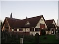
Notes
- Clicking on the map will re-center to the selected point.
- The higher the marker number, the further away the image location is from the centre of the postcode.
Image Listing (79 Images Found)
Images are licensed for reuse under creativecommons.org/licenses/by-sa/2.0
Image
Details
Distance
1
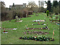
Oxted burial ground
The corner currently in use for most new burials. The burial ground is operated by the local council - over the hedge and stream on the left is an uncared for graveyard that seems to be an annex of the churchyard, and the responsibility of the church.
Image: © Robin Webster
Taken: 28 Jan 2011
0.06 miles
2
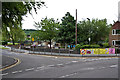
Junction of Silkham Road and Chichele Road
In the background is St Marys Junior School.
Image: © Ian Capper
Taken: 3 Jul 2013
0.07 miles
3
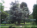
Cedar tree, burial ground Oxted
Besides this large Atlas Cedar tree, there are numerous other specimen trees in this vicinity and it could, perhaps, be classed as an arboretum.
Image: © Brian Green
Taken: 13 Jun 2007
0.09 miles
5
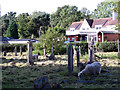
Grazing in the shadows
Oxted churchyard is grazed by sheep, an ancient practice.
Image: © Stephen Craven
Taken: 13 Sep 2012
0.13 miles
6
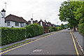
Chicele Road
Early 20th Century development (the road first appears on the 1910 6 inch map, partially built).
Image: © Ian Capper
Taken: 3 Jul 2013
0.14 miles
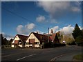
8
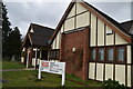
Oxted Community Hall
Although the construction of this building in 2007 to replace the old church hall was a church-led project, and it was built on part of the churchyard, it was intended very much as a resource for the whole community. So the land ownership and operation of the centre were transferred to an independent management committee. It has its own website: http://www.oxtedcommunityhall.org.uk/
Image: © Stephen Craven
Taken: 13 Sep 2012
0.14 miles
9
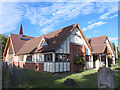
Oxted Village Hall
On Barrow Green Road, near St Mary's Church.
Image: © David Anstiss
Taken: 27 Nov 2011
0.14 miles
10
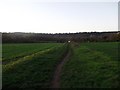
Bridleway to Barrow Green Road
This field path leads from St Mary's Church in Oxted, towards the road.
In the background is the North Downs.
Image: © David Anstiss
Taken: 27 Nov 2011
0.14 miles