IMAGES TAKEN NEAR TO
Moor Lane, LINGFIELD, RH7 6NX
Introduction
This page details the photographs taken nearby to Moor Lane, RH7 6NX by members of the Geograph project.
The Geograph project started in 2005 with the aim of publishing, organising and preserving representative images for every square kilometre of Great Britain, Ireland and the Isle of Man.

There are currently over 7.5m images from over14,400 individuals and you can help contribute to the project by visiting https://www.geograph.org.uk
Image Map
Images are licensed for reuse under creativecommons.org/licenses/by-sa/2.0
Notes
- Clicking on the map will re-center to the selected point.
- The higher the marker number, the further away the image location is from the centre of the postcode.
Image Listing (11 Images Found)
Images are licensed for reuse under creativecommons.org/licenses/by-sa/2.0
Image
Details
Distance
1
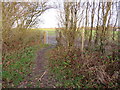
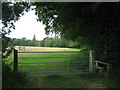
Footpath and gate near Dormansland
A public footpath passes through a gate into a field in the Surrey countryside.
The arrows on the marker post indicate that another path heads away to the left.
Image: © Malc McDonald
Taken: 14 Dec 2019
0.08 miles
2
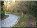
Moor Lane, near Dormansland
Moor Lane is a 'B' road through Surrey countryside. It forms part of the B2028.
Image: © Malc McDonald
Taken: 14 Dec 2019
0.09 miles
3
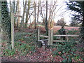
Footpath and stile near Dormansland
A stile leading onto a public footpath in the Surrey countryside, near Dormansland.
This image was taken in the month of December, after trees had shed their leaves for winter. Dead leaves were slowly decomposing on the ground.
Image: © Malc McDonald
Taken: 14 Dec 2019
0.12 miles
4
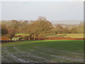
Surrey countryside, near Dormansland
A view of Surrey countryside, looking towards the North Downs, taken from a footpath near Dormansland.
This image was taken on a December afternoon. The sun was low in the sky, casting long shadows.
Image: © Malc McDonald
Taken: 14 Dec 2019
0.14 miles
7
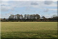
Footpath in a field, near Dormansland
A public footpath runs along the edge of this field, in Surrey countryside.
This image was taken on a December afternoon. The sun was low in the sky, casting long shadows.
Image: © Malc McDonald
Taken: 14 Dec 2019
0.19 miles
8
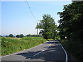
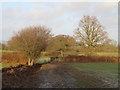
Looking east along Moor Lane (B2028), Surrey
Many second-class and even unclassified roads in this area carry high traffic densities - car ownership is virtually universal and public transport not usually available. But the B2028, which leads from Dormansland in Surrey to Edenbridge in Kent, does have its quiet moments, as seen here. At this point the road is known as Moor Lane.
Image: © Dr Neil Clifton
Taken: 3 Jul 2006
0.20 miles
9
Footpath in a field, near Dormansland
A public footpath runs along the edge of this field in the Surrey countryside.
This image was taken on a December afternoon. The sun was low in the sky, casting long shadows.
Image: © Malc McDonald
Taken: 14 Dec 2019
0.24 miles
10
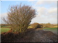
Gate and stile near Carewell Wood
The stile is on a footpath leads from the B2028 Race Course Road, towards St.Piers Lane.
On the right is Carewell Wood.
Image: © David Anstiss
Taken: 10 Jul 2011
0.24 miles