IMAGES TAKEN NEAR TO
Clay Lane, LINGFIELD, RH7 6HX
Introduction
This page details the photographs taken nearby to Clay Lane, RH7 6HX by members of the Geograph project.
The Geograph project started in 2005 with the aim of publishing, organising and preserving representative images for every square kilometre of Great Britain, Ireland and the Isle of Man.

There are currently over 7.5m images from over14,400 individuals and you can help contribute to the project by visiting https://www.geograph.org.uk
Image Map
Images are licensed for reuse under creativecommons.org/licenses/by-sa/2.0
Notes
- Clicking on the map will re-center to the selected point.
- The higher the marker number, the further away the image location is from the centre of the postcode.
Image Listing (14 Images Found)
Images are licensed for reuse under creativecommons.org/licenses/by-sa/2.0
Image
Details
Distance
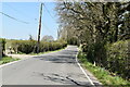
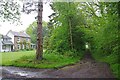
1
Horne Footpath 280
This footpath leads to the Eastbourne Road.
Image: © Glyn Baker
Taken: 2 May 2024
0.05 miles
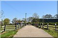
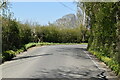
3
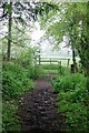
Gate on Clay Lane
A gate across Horne Bridleway 326.
Image: © Glyn Baker
Taken: 2 May 2024
0.08 miles
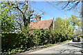
4
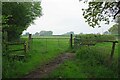
Footpath 363 Bridleway 326 Junction
Image is over the stile. The bridleway bares right through the small gate and runs parallel to the hedge.
Image: © Glyn Baker
Taken: 2 May 2024
0.08 miles
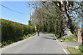
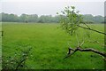
7
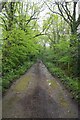
Clay Lane
Horne Bridleway 326 this leads to East Bysshe Farm after which the right of way becomes Image
Image: © Glyn Baker
Taken: 2 May 2024
0.15 miles