IMAGES TAKEN NEAR TO
Lake Lane, Langshott, HORLEY, RH6 9LL
Introduction
This page details the photographs taken nearby to Lake Lane, Langshott, RH6 9LL by members of the Geograph project.
The Geograph project started in 2005 with the aim of publishing, organising and preserving representative images for every square kilometre of Great Britain, Ireland and the Isle of Man.

There are currently over 7.5m images from over14,400 individuals and you can help contribute to the project by visiting https://www.geograph.org.uk
Image Map
Images are licensed for reuse under creativecommons.org/licenses/by-sa/2.0
Notes
- Clicking on the map will re-center to the selected point.
- The higher the marker number, the further away the image location is from the centre of the postcode.
Image Listing (14 Images Found)
Images are licensed for reuse under creativecommons.org/licenses/by-sa/2.0
Image
Details
Distance
1
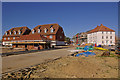
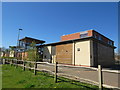
Brookfield Way, The Acres
Building work on a major new development north-east of Horley.
Image: © Ian Capper
Taken: 26 Apr 2009
0.13 miles
2
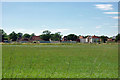
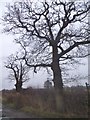
Greenfield development north of Horley
This is a major development on green fields, probably once looking similar to that in the foreground!
Image: © Robin Webster
Taken: 18 Jul 2010
0.14 miles
3
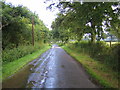
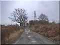
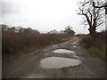
Horley: Lake Lane
Looking towards Greatlake Farm.
Image: © Nigel Cox
Taken: 18 Aug 2006
0.14 miles
4
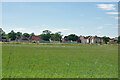
Housing advancing over green fields, Horley 2010
The green fields were soon built over.
Image: © Robin Webster
Taken: 18 Jul 2010
0.15 miles
8
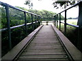
Footbridge across Burstow Stream
From here, Burstow Stream flows west to join the River Mole
Image: © Rib
Taken: 11 Aug 2005
0.24 miles
10
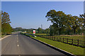
Orchard Drive
Not yet shown on maps at the date of submission. Orchard Drive links Cross Oak Lane and Langshott, giving access to a new development, The Acres. This is the middle section, just south of where it crosses Burstow Stream. The fending round the trees on the right are to protect them from damage during building work, as the site expands.
Image: © Ian Capper
Taken: 26 Apr 2009
0.24 miles