IMAGES TAKEN NEAR TO
Apperlie Drive, HORLEY, RH6 9EU
Introduction
This page details the photographs taken nearby to Apperlie Drive, RH6 9EU by members of the Geograph project.
The Geograph project started in 2005 with the aim of publishing, organising and preserving representative images for every square kilometre of Great Britain, Ireland and the Isle of Man.

There are currently over 7.5m images from over14,400 individuals and you can help contribute to the project by visiting https://www.geograph.org.uk
Image Map
Images are licensed for reuse under creativecommons.org/licenses/by-sa/2.0
Notes
- Clicking on the map will re-center to the selected point.
- The higher the marker number, the further away the image location is from the centre of the postcode.
Image Listing (33 Images Found)
Images are licensed for reuse under creativecommons.org/licenses/by-sa/2.0
Image
Details
Distance
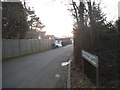
1
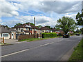
The Coronet, Horley
An aptly named ring of houses on the southern outskirts of Horley.
Image: © Jean Barrow
Taken: 25 Aug 2006
0.04 miles
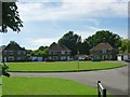
2
The Coronet, Horley
A horseshoe arrangement of houses around a green.
Image: © Robin Webster
Taken: 21 May 2022
0.04 miles
3
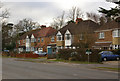
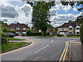
Balcombe Road
The Balcombe Road dates from 1809 when a turnpike was built to Cuckfield. This section was largely developed in the 1920s/30s.
Image: © Ian Capper
Taken: 9 Mar 2010
0.06 miles
4
Bus stop, Balcombe Road, Horley
The terminus of the three days a week 'Hail and Ride' route 26 is a bit further south at Meadowcroft Close. This is the 'Horley Town Service' that has a convoluted route around town fitting in the local supermarkets. The bus will stop 'at any safe point in the residential areas', so why this stop?
Image: © Robin Webster
Taken: 21 May 2022
0.07 miles
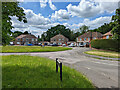
5
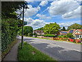
Haroldslea Drive meets Balcombe Road, Horley
Image: © Robin Webster
Taken: 21 May 2022
0.08 miles
6
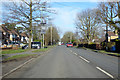
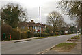
B2036 Balcombe Road, Horley
Heading north just inside the start of the 30 mph limit.
Image: © Robin Webster
Taken: 7 Feb 2018
0.08 miles
8
Balcombe Road
The Balcombe Road dates from 1809 when a turnpike was built to Cuckfield. This section was largely developed in the 1920s/30s.
Image: © Ian Capper
Taken: 9 Mar 2010
0.09 miles
9
Bayhorne Lane, Horley
Mainly to the small Bayhorne Lane Industrial Estate.
Image: © Robin Webster
Taken: 21 May 2022
0.10 miles