IMAGES TAKEN NEAR TO
Kingfisher Close, HORLEY, RH6 8TL
Introduction
This page details the photographs taken nearby to Kingfisher Close, RH6 8TL by members of the Geograph project.
The Geograph project started in 2005 with the aim of publishing, organising and preserving representative images for every square kilometre of Great Britain, Ireland and the Isle of Man.

There are currently over 7.5m images from over14,400 individuals and you can help contribute to the project by visiting https://www.geograph.org.uk
Image Map
Images are licensed for reuse under creativecommons.org/licenses/by-sa/2.0
Notes
- Clicking on the map will re-center to the selected point.
- The higher the marker number, the further away the image location is from the centre of the postcode.
Image Listing (38 Images Found)
Images are licensed for reuse under creativecommons.org/licenses/by-sa/2.0
Image
Details
Distance
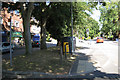
4
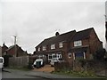
Vicarage Lane
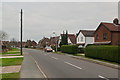
Originally to be called Vicarage Road (and shown as such on the 1912 large scale map), but actually named Vicarage Lane after someone wrongly made the road sign. It formed the western boundary of Horley Common, and still contains a few old cottages built on the common edge. More general building took place from the 1930s onwards. The Vicarage itself was demolished in the early 1960s and replaced with a short close, The Glebe (see Image).
Image: © Ian Capper
Taken: 11 Sep 2011
0.06 miles
5
Vicarage Lane
Originally to be called Vicarage Road (and shown as such on the 1912 large scale map), but actually named Vicarage Lane after someone wrongly made the road sign. It formed the western boundary of Horley Common, and still contains a few old cottages built on the common edge. More general building took place from the 1930s onwards. The Vicarage itself was demolished in the early 1960s and replaced with a short close, The Glebe (see Image).
Image: © Ian Capper
Taken: 8 Jan 2012
0.07 miles
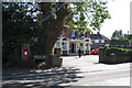
6
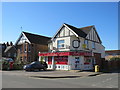
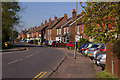
A Corner Shop in Horley
One of many that has stayed open and is doing a great job serving local customers during the Coronavirus.
Image: © Richard Rogerson
Taken: 5 Apr 2020
0.08 miles
7
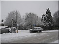
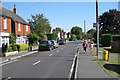
Junction of Meath Green Lane with Horley Row, Horley Surrey
Image: © Richard Rogerson
Taken: 6 Jan 2010
0.09 miles
8
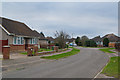
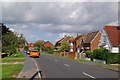
Blundell Avenue
A road off Vicarage Lane, developed in 1955, named after a local family.
Image: © Ian Capper
Taken: 8 Jan 2012
0.10 miles
10
The Bull public house, Horley Row
Postbox ID: RH6 224
Image: © Robin Stott
Taken: 31 Aug 2009
0.11 miles