IMAGES TAKEN NEAR TO
Eames Crescent, RH6 8QD
Introduction
This page details the photographs taken nearby to Eames Crescent, RH6 8QD by members of the Geograph project.
The Geograph project started in 2005 with the aim of publishing, organising and preserving representative images for every square kilometre of Great Britain, Ireland and the Isle of Man.

There are currently over 7.5m images from over14,400 individuals and you can help contribute to the project by visiting https://www.geograph.org.uk
Image Map
Images are licensed for reuse under creativecommons.org/licenses/by-sa/2.0
Notes
- Clicking on the map will re-center to the selected point.
- The higher the marker number, the further away the image location is from the centre of the postcode.
Image Listing (5 Images Found)
Images are licensed for reuse under creativecommons.org/licenses/by-sa/2.0
Image
Details
Distance
1
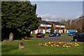
Mill Close
1970s housing off Lee Street. On the left is part of the Lee Street Burial Ground (see Image).
Image: © Ian Capper
Taken: 3 Apr 2011
0.23 miles
2
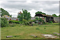
Landens Farm, Meath Green, 2010
Now mostly demolished with the stable block converted to housing, and surrounded by housing.
Image: © Robin Webster
Taken: 18 Jul 2010
0.23 miles
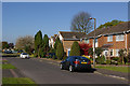
5
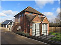
Farm Building Conversion, Horley
This was the Grainary at Landens Farm. It has been converted into a three bedroomed house as part of the new Malthouse Lane development on the north western side of Horley. This image Image shows the building in February 2008, before renovation.
Image: © Richard Rogerson
Taken: 10 Mar 2019
0.25 miles