IMAGES TAKEN NEAR TO
Day Close, HORLEY, RH6 8GT
Introduction
This page details the photographs taken nearby to Day Close, RH6 8GT by members of the Geograph project.
The Geograph project started in 2005 with the aim of publishing, organising and preserving representative images for every square kilometre of Great Britain, Ireland and the Isle of Man.

There are currently over 7.5m images from over14,400 individuals and you can help contribute to the project by visiting https://www.geograph.org.uk
Image Map
Images are licensed for reuse under creativecommons.org/licenses/by-sa/2.0
Notes
- Clicking on the map will re-center to the selected point.
- The higher the marker number, the further away the image location is from the centre of the postcode.
Image Listing (38 Images Found)
Images are licensed for reuse under creativecommons.org/licenses/by-sa/2.0
Image
Details
Distance
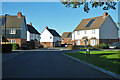
1
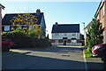
Cinderfield Road, Westvale Park, Horley
In this rather new greenfield development.
Image: © Robin Webster
Taken: 18 Nov 2022
0.06 miles
2
Houses on Moy Green Drive, Westvale Park, Horley
In this rather new greenfield development.
Image: © Robin Webster
Taken: 18 Nov 2022
0.06 miles
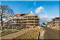
3
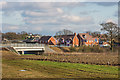
Westvale Park
Major development on the northern outskirts of Horley, with the first stage involving 600 new houses, which is due to more than double in later stages. This photo show some of the first buildings, close to completion.
Image: © Ian Capper
Taken: 17 Feb 2017
0.08 miles
4
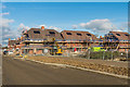
Westvale Park
Major development on the northern outskirts of Horley, with the first stage involving 600 new houses, which is due to more than double in later stages. This photo show some of the first buildings under construction.
Image: © Ian Capper
Taken: 17 Feb 2017
0.08 miles
5
Westvale Park
Major development on the northern outskirts of Horley, with the first stage involving 600 new houses, which is due to more than double in later stages. This photo show some of the first buildings close to completion, beyond a new bridge over the River Mole completed in 2016 giving access to the area from the A217.
Image: © Ian Capper
Taken: 17 Feb 2017
0.09 miles
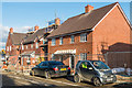
6
Turnstone Court, Westvale Park, Horley
Flats in this rather new greenfield development.
Image: © Robin Webster
Taken: 18 Nov 2022
0.09 miles
7
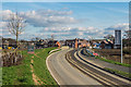
Westvale Park
Major development on the northern outskirts of Horley, with the first stage involving 600 new houses, which is due to more than double in later stages. This photo shows the access road into the site from the A217. Beyond are some of the first buildings, close to completion.
Image: © Ian Capper
Taken: 17 Feb 2017
0.10 miles
8
Westvale Park
Major development on the northern outskirts of Horley, with the first stage involving 600 new houses, which is due to more than double in later stages. This photo show some of the first buildings, close to completion.
Image: © Ian Capper
Taken: 17 Feb 2017
0.10 miles
9
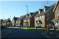
In Westvale Park, Horley
A rather new greenfield development.
Image: © Robin Webster
Taken: 18 Nov 2022
0.11 miles
10
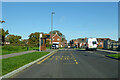
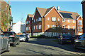
Webber Street, Westvale Park, Horley
The bus stop, served by routes 422 and 424, is called Tanner Crescent, which is a right turn ahead, closer to the stop for the other direction.
Image: © Robin Webster
Taken: 18 Nov 2022
0.12 miles