IMAGES TAKEN NEAR TO
Whitmore Way, HORLEY, RH6 8FX
Introduction
This page details the photographs taken nearby to Whitmore Way, RH6 8FX by members of the Geograph project.
The Geograph project started in 2005 with the aim of publishing, organising and preserving representative images for every square kilometre of Great Britain, Ireland and the Isle of Man.

There are currently over 7.5m images from over14,400 individuals and you can help contribute to the project by visiting https://www.geograph.org.uk
Image Map
Images are licensed for reuse under creativecommons.org/licenses/by-sa/2.0
Notes
- Clicking on the map will re-center to the selected point.
- The higher the marker number, the further away the image location is from the centre of the postcode.
Image Listing (35 Images Found)
Images are licensed for reuse under creativecommons.org/licenses/by-sa/2.0
Image
Details
Distance
1
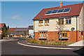
New houses, Whitmore Way
A development of "affordable housing" consisting of 20 houses and 16 flats on the site of a former depot off Lee Street, completed in the summer of 2012.
Image: © Ian Capper
Taken: 15 Sep 2012
0.01 miles
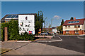
2

New houses, Whitmore Way
A development of "affordable housing" consisting of 20 houses and 16 flats on the site of a former depot off Lee Street.
Image: © Ian Capper
Taken: 15 Jan 2012
0.02 miles
3
New houses, Whitmore Way
A development of "affordable housing" consisting of 20 houses and 16 flats on the site of a former depot off Lee Street, completed in the summer of 2012.
Image: © Ian Capper
Taken: 15 Sep 2012
0.02 miles
4
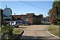
Sewage works off Lee Street, Horley
Operated by Thames Water. Close to the River Mole.
Image: © Robin Stott
Taken: 31 Aug 2009
0.03 miles
5
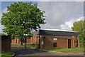
Brethren Meeting Room
A modern Brethren Meeting Room in Whitmore Way, off Lee Street.
Image: © Ian Capper
Taken: 11 Sep 2011
0.05 miles
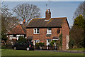
6
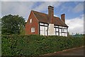
The Cottage
17th century house in Whitmore Way, off Lee Street. Grade II listed - for listing particulars see www.historicengland.org.uk/listing/the-list/list-entry/1178299.
Image: © Ian Capper
Taken: 11 Sep 2011
0.05 miles
7
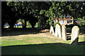
Lee Street burial ground, Mill Close, Horley
The open space in Mill Close was created to preserve a burial ground and its graves. It was the last resting-place of Strict and Particular Baptists between 1852 and 1969. The sect worshipped in the adjoining chapel, now demolished. This information comes from a small sign on the site.
Image: © Robin Stott
Taken: 31 Aug 2009
0.07 miles
8
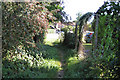
Public footpath approaches Lee Street, Horley
Image: © Robin Stott
Taken: 31 Aug 2009
0.07 miles
9
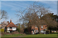
Lee Street
Two cottages in Lee Street. On the left is The Old House, a grade II listed house dating from the 16th century - see www.historicengland.org.uk/listing/the-list/list-entry/1295115.
Image: © Ian Capper
Taken: 3 Apr 2011
0.10 miles
10
Lee Street
Two cottages in Lee Street. On the left is The Old House, a grade II listed house dating from the 16th century - see www.historicengland.org.uk/listing/the-list/list-entry/1295115.
Image: © Ian Capper
Taken: 3 Apr 2011
0.10 miles