IMAGES TAKEN NEAR TO
Carlton Court, Sarel Way, HORLEY, RH6 8EZ
Introduction
This page details the photographs taken nearby to Carlton Court, Sarel Way, RH6 8EZ by members of the Geograph project.
The Geograph project started in 2005 with the aim of publishing, organising and preserving representative images for every square kilometre of Great Britain, Ireland and the Isle of Man.

There are currently over 7.5m images from over14,400 individuals and you can help contribute to the project by visiting https://www.geograph.org.uk
Image Map
Images are licensed for reuse under creativecommons.org/licenses/by-sa/2.0
Notes
- Clicking on the map will re-center to the selected point.
- The higher the marker number, the further away the image location is from the centre of the postcode.
Image Listing (35 Images Found)
Images are licensed for reuse under creativecommons.org/licenses/by-sa/2.0
Image
Details
Distance
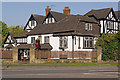
1
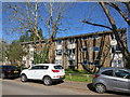
Carlton Court, Horley
Residential block built in the 1960's or 70's.
Image: © Richard Rogerson
Taken: 5 Apr 2020
0.00 miles
2
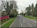
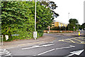
A23 Bonehurst Road
Heading north away from Horley, the next major town being Redhill.
Image: © Robin Webster
Taken: 23 Mar 2019
0.04 miles
3
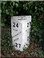
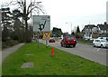
Between Westminster Bridge and Brighton
A milestone on the A23 in the Parish of Horley.
Image: © Mary and Angus Hogg
Taken: 6 Mar 2008
0.05 miles
4
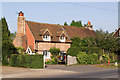
Forge Cottage, Bonehurst Road
17th century cottage, suitably sited on the Brighton Turnpike to serve as a forge. Grade II listed - for listing particulars see www.historicengland.org.uk/listing/the-list/list-entry/1378014.
Image: © Ian Capper
Taken: 10 Oct 2010
0.07 miles
5
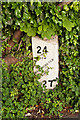
Milepost, Bonehurst Road
Close up of the cast iron milepost in Image and Image This of a standard design for mileposts along this route, which was built in 1816 as a direct route from Gatton Point, north of Redhill, to Povey Cross, near Gatwick.
The post shows the distances to/from Brighton and Westminster Bridge on the two faces, but in a different order according to the direction of travel. On the top face is the locality (here the Parish of Horley).
Image: © Ian Capper
Taken: 13 Jun 2012
0.07 miles
6
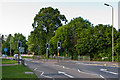
Bonehurst Road
The A23 in Horley just north of the Chequers roundabout, junction for the Balcombe Road. The road dates from 1816 as the direct route from Gatton Point, north of Redhill, to Povey Cross, near Gatwick. On the far right is the milepost in Image
Image: © Ian Capper
Taken: 13 Jun 2012
0.07 miles
7
Bonehurst Road
The A23 in Horley just north of the Chequers roundabout, junction for the Balcombe Road (seen in the background). The road dates from 1816 as the direct route from Gatton Point, north of Redhill, to Povey Cross, near Gatwick. On the left is the milepost in Image
Image: © Ian Capper
Taken: 13 Jun 2012
0.08 miles
8
Approaching The Roundabout
Approaching the junction of the A23 and the B2036 in Horley.
Image: © Mary and Angus Hogg
Taken: 6 Mar 2008
0.08 miles
9
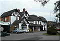
Chequers Hotel
One of many hotels in this area which cater for people travelling via Gatwick Airport.
Image: © Mary and Angus Hogg
Taken: 6 Mar 2008
0.08 miles
10
Chequers Hotel
Dating originally from the 16th century (the central section with the sundial is part of the original build), but much altered and added to over the years. It is locally listed.
Image: © Ian Capper
Taken: 10 Oct 2010
0.09 miles