IMAGES TAKEN NEAR TO
Yew Tree Close, Horley Row, HORLEY, RH6 8DL
Introduction
This page details the photographs taken nearby to Yew Tree Close, Horley Row, RH6 8DL by members of the Geograph project.
The Geograph project started in 2005 with the aim of publishing, organising and preserving representative images for every square kilometre of Great Britain, Ireland and the Isle of Man.

There are currently over 7.5m images from over14,400 individuals and you can help contribute to the project by visiting https://www.geograph.org.uk
Image Map
Images are licensed for reuse under creativecommons.org/licenses/by-sa/2.0
Notes
- Clicking on the map will re-center to the selected point.
- The higher the marker number, the further away the image location is from the centre of the postcode.
Image Listing (40 Images Found)
Images are licensed for reuse under creativecommons.org/licenses/by-sa/2.0
Image
Details
Distance
1
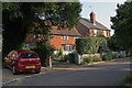
Yew Tree Close
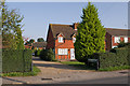
Old maps show a row of cottages on Horley Row separated from the road (originally a track) by an area of open ground, being the northern edge of what was Horley Common. A number of these cottages survive, but they are now separated from (and largely hidden from sight from) the road by more recent buildings. Monks Cottage, seen here, is an example. It dates from the 17th century and is grade II listed - for listing particulars see www.historicengland.org.uk/listing/the-list/list-entry/1378000.
Image: © Ian Capper
Taken: 10 Oct 2010
0.02 miles
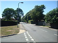
3
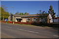
Wheelwrights Court
A short close off Horley Row, which gives access to some of the cottages shown on older maps separated from the road (originally a track) by an area of open ground, being the northern edge of what was Horley Common. They are now separated from (and largely hidden from sight from) the road by more recent buildings. Lydford, in the background, a 17th century grade II listed cottage, is one example of these - for listing particulars see www.historicengland.org.uk/listing/the-list/list-entry/1378038. The barn on the left was originally a wheelwright's shop (hence the name of the close). It later became the building yard of local builders, Andersons, who developed much of the area south of Horley Row. The barn has since been converted into a house. Dating originally from around 1700, it too is grade II listed - for listing particulars see www.historicengland.org.uk/listing/the-list/list-entry/1378024.
Image: © Ian Capper
Taken: 10 Oct 2010
0.03 miles
5
Wheelwrights Court
A short close off Horley Row, which gives access to some of the cottages shown on older maps separated from the road (originally a track) by an area of open ground, being the northern edge of what was Horley Common. They are they are now separated from (and largely hidden from sight from) the road by more recent buildings.
Image: © Ian Capper
Taken: 10 Oct 2010
0.04 miles
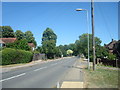
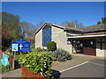
6
St Wilfrid's Church, Horley
The present building dates from 1970, although services were first held here in 1937, in a school that previously stood on the site. It is one of three churches in the Horley Team, along with St Bart's (see Image) and St Francis' (see Image).
Image: © Ian Capper
Taken: 26 Apr 2009
0.04 miles
7
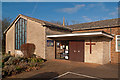
St Wilfrid's Church, Horley
The present building dates from 1970, although services were first held here in 1937, in a school that previously stood on the site. It is one of three churches in the Horley Team, along with St Bart's (see Image) and St Francis' (see Image).
For close up of foundation stone below window on left of photo, see Image
Image: © Ian Capper
Taken: 22 Jan 2012
0.04 miles
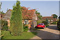
8
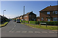
Southlands Avenue
1950s housing off Horley Row.
Image: © Ian Capper
Taken: 26 Apr 2009
0.04 miles
9

Foundation stone of St Wilfrid's Church
See Image for photo of church, and showing the position of the stone below the window to the left of that photo.
The stone reads: "To the greater glory of God. This stone was laid on October 11th 1969 by Sir Barnes Wallis CBE DSc FRS, Treasurer of Christ's Hospital."
The connection with Sir Barnes Wallis (of Dam Busters fame) and Christ's Hospital? Christ's Hospital was a major landowner in Horley, and they are the patrons of Horley parish, of which St Wilf's is a part, and as the stone states, Sir Barnes Wallis was its treasurer (as well as being an old boy of the school).
Image: © Ian Capper
Taken: 8 Jan 2012
0.05 miles
10
St Wilfred's Church, Horley
St Wilfrid’s church started life in an old school which was converted to a church in 1958. The first service was held on Friday September 19 1958.
The foundation stone for the actual church was laid in October 1969 by Sir Barnes Wallis, of bouncing bomb fame, who was a former student at Christ’s Hospital School, where he later served as treasurer.
The church and community hall was dedicated on October 14 1970.
Image: © Richard Rogerson
Taken: 5 Apr 2020
0.05 miles