IMAGES TAKEN NEAR TO
Victoria Road, HORLEY, RH6 7PZ
Introduction
This page details the photographs taken nearby to Victoria Road, RH6 7PZ by members of the Geograph project.
The Geograph project started in 2005 with the aim of publishing, organising and preserving representative images for every square kilometre of Great Britain, Ireland and the Isle of Man.

There are currently over 7.5m images from over14,400 individuals and you can help contribute to the project by visiting https://www.geograph.org.uk
Image Map
Images are licensed for reuse under creativecommons.org/licenses/by-sa/2.0
Notes
- Clicking on the map will re-center to the selected point.
- The higher the marker number, the further away the image location is from the centre of the postcode.
Image Listing (158 Images Found)
Images are licensed for reuse under creativecommons.org/licenses/by-sa/2.0
Image
Details
Distance
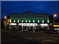
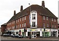
1

Collingwood and Batchellor
This long established independent department store has recently gone through a major refurbishment, completed in 2007.
Image: © Ian Capper
Taken: 17 Jan 2009
0.04 miles
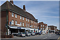
2
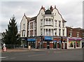
Horley: High Street and Victoria Road
The High Street is to the left and Victoria Road to the right in this image. The High Street was once called Station Road, but the name had to be changed when the railway moved the station some 300 metres southwards in 1905. From this location one now needs to follow Victoria Road to get to the station.
The attractive corner building with its Dutch gables is Number 2 High Street. As a sign of the times it currently houses a branch of the Cheque Centre, although the photographer thinks that it was formerly occupied by a branch of the estate agents Gascoigne Pees.
Image: © Nigel Cox
Taken: 9 Dec 2012
0.04 miles
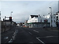
3
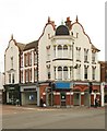
Victoria Road/High Street junction, Horley
Idiosynchratic display of architectural styles, with empty retail units.
Image: © Jim Osley
Taken: 5 Sep 2014
0.04 miles
4
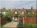
The garden to the rear of the Horley Bookshop
This photo is taken from the Consort Way car park. Overgrown and redundant. About to get a new lease of life!
Image: © Peter Tracey
Taken: Unknown
0.05 miles
5
The Jack Fairman, Horley
The Jack Fairman Pub is on the site of a former Kwikfit Tyre Centre. It was opened on 12 February 2007. Jack Fairman (1913-2002) was born in Horley. He was a racing driver who took part in 12 Grand Prix races from 1953 to 1963. The building in Victoria Road Horley was built in 1933 in Art Deco style as a car showroom for the Fairman Family.
Image: © Richard Rogerson
Taken: 17 Feb 2009
0.05 miles
6
Victoria Way at the junction of Consort Road, Horley
Image: © David Howard
Taken: 29 Mar 2015
0.05 miles
7
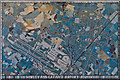
Horley Millennium Mosaic
Situated in High Street (see Image for wider view), the mosaic was commissioned by Horley Town Council to commemorate the Millennium, being unveiled on 2 December 2000. It was designed and made by the Mosaic Workshop in Holloway Road, London, and paid for by local builders' merchants, Mitchells of Horley, who were celebrating their centenary that year.
It depicts Gatwick Airport on the left of the mosaic and with Horley itself covering much of the right hand side, bisected by the diagonal line of the London to Brighton railway.
Image: © Ian Capper
Taken: 27 May 2013
0.05 miles
8
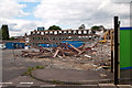
Newman House - demolition
1970s office block, which for many years served as headquarters of what became the UK's largest independent airline, Dan-Air, until its takeover by British Airways in 1992.
In this photo the building is part demolished, as part of a Horley town centre regeneration project.
Image: © Ian Capper
Taken: 18 Jun 2012
0.05 miles
9
Horley: Central Parade
According to the date carved high up in the stone tablet this building dates from 1937. Massetts Road is to the left and Victoria Road is to the right. The address of Cubitt & West, the estate agents occupying the prominent corner location, is 101 Victoria Road http://www.cubittandwest.co.uk/branch-directory/branch-details.asp?BranchID=208 .
Image: © Nigel Cox
Taken: 9 Dec 2012
0.05 miles
10
Central Parade
Shopping parade in Massetts Road at its junction with Victoria Road and High Street.
Image: © Ian Capper
Taken: 26 May 2013
0.06 miles