IMAGES TAKEN NEAR TO
Lumley Road, HORLEY, RH6 7JX
Introduction
This page details the photographs taken nearby to Lumley Road, RH6 7JX by members of the Geograph project.
The Geograph project started in 2005 with the aim of publishing, organising and preserving representative images for every square kilometre of Great Britain, Ireland and the Isle of Man.

There are currently over 7.5m images from over14,400 individuals and you can help contribute to the project by visiting https://www.geograph.org.uk
Image Map
Images are licensed for reuse under creativecommons.org/licenses/by-sa/2.0
Notes
- Clicking on the map will re-center to the selected point.
- The higher the marker number, the further away the image location is from the centre of the postcode.
Image Listing (136 Images Found)
Images are licensed for reuse under creativecommons.org/licenses/by-sa/2.0
Image
Details
Distance
1
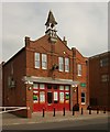
Former fire station, Horley
Locally listed fire station built 1901-1902. There is modern extension (built in a complementary style) and since 2011 the building has been home to Horley Young People's Centre.
Image: © Jim Osley
Taken: 5 Sep 2014
0.03 miles
2
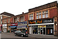
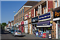
High Street
Shops on the north side of High Street.
Image: © Ian Capper
Taken: 6 Nov 2011
0.03 miles
3

High Street
Originally a section of Station Road, this western stretch was cut off from the eastern stretch (still called Station Road) in 1903 as a consequence of the quadrupling of the London to Brighton railway, with the station being moved at the same time (see Image for further explanation). However, despite having no connection with the station, this section was not renamed High Street until almost 60 years later, in 1961.
Image: © Ian Capper
Taken: 25 Jul 2009
0.04 miles
4
Horley: Former fire station
Please see Richard's Image] for a view in 2006 prior to the extension on the right being built, and Ian's Image] for a view in 2011 and a good history of the building. In each image the clock is resolutely stopped at 1:46! The letters HPC are carved into the stone tablet underneath the cupola, possibly standing for Horley Parish Council who might have had responsibility for the fire service in the early 1900s?
Image: © Nigel Cox
Taken: 9 Dec 2012
0.04 miles
5
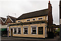
The Gatwick
Originally built in the 1850s as a private house called Raglan House, it is not clear when it formally became a pub or acquired its name, although there was a brewery, the Station Brewery, situated immediately behind the building between at least 1867 and 1874. Records show that it certainly was fully running as a pub by 1890. The name "The Gatwick" is nothing to do with the airport, but instead Gatwick racecourse (on which the current airport is built), with horses being unloaded from trains in the nearby station yard, for leading to the racecourse.
Image: © Ian Capper
Taken: 6 Nov 2011
0.04 miles
6
High Street
An ornate terracotta fronted building on High Street.
Image: © Ian Capper
Taken: 27 May 2013
0.04 miles
7
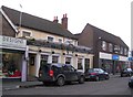
Horley: The Gatwick
Named after the long since defunct Gatwick Racecourse, and hence the horseshoe sign, the pub is a Hall & Woodhouse outlet on the High Street. At the time of submission the owners were seeking new landlords.
Image: © Nigel Cox
Taken: 9 Dec 2012
0.04 miles
8
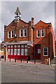
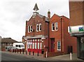
Old Horley Fire Station
The former fire station in Albert Road. It was built in around 1902 by Arthur Jennings, to a design of Mr C H Burrows of Horsham, and was in use as a fire station until 1966, after which it saw various commercial uses. It has since been refurbished and extended and is now a Surrey County Council youth centre, opened on 6 September 2010.
The building is locally listed. For photo in 2008, when still in commercial use and before being extended, see Image
Image: © Ian Capper
Taken: 18 Sep 2011
0.04 miles
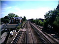
9
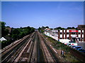
Railway Track at Horley
London to Brighton line looking north. View from footbridge that connects Yattendon Road/High Street to Station Road/Station Approach
Image: © Rib
Taken: 11 Jul 2006
0.04 miles
10
Railway Track at Horley
London to Brighton line looking south. View from footbridge that connects Yattendon Road/High Street to Station Road/Station Approach.
Image: © Rib
Taken: 11 Jul 2006
0.04 miles