IMAGES TAKEN NEAR TO
Horsehill, HORLEY, RH6 0HN
Introduction
This page details the photographs taken nearby to Horsehill, RH6 0HN by members of the Geograph project.
The Geograph project started in 2005 with the aim of publishing, organising and preserving representative images for every square kilometre of Great Britain, Ireland and the Isle of Man.

There are currently over 7.5m images from over14,400 individuals and you can help contribute to the project by visiting https://www.geograph.org.uk
Image Map
Images are licensed for reuse under creativecommons.org/licenses/by-sa/2.0
Notes
- Clicking on the map will re-center to the selected point.
- The higher the marker number, the further away the image location is from the centre of the postcode.
Image Listing (18 Images Found)
Images are licensed for reuse under creativecommons.org/licenses/by-sa/2.0
Image
Details
Distance
1
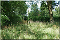
Gate at end of footpath 414 Salfords & Sidlow
The road called Horse Hill is beyond.
Image: © Robin Webster
Taken: 18 Jul 2010
0.03 miles
3
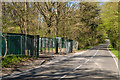
Oil exploration site entrance, Horse Hill
Horse Hill was the original Brighton Road, before the more direct route (now the A217) was built, itself superseded by the current A23 in 1818.
In 2015, the name received prominence following the announcement that a trial drilling off Horse Hill had suggested the existence of between 50bn and 100bn barrels of oil under an area of the Weald Basin in Surrey and East and West Sussex, and whilst it was likely that only a small proportion could be readily recovered, it could still provide a significant proportion of the UK oil needs for a period. However subsequent reports have tried to downplay the news, over concerns of commercial viability of the find.
This is the entrance to the exploration site, off Horse Hill. For closer view see Image
Image: © Ian Capper
Taken: 18 Apr 2015
0.04 miles
4
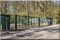
Oil exploration site entrance, Horse Hill
Entrance to the Horse Hill oil exploration site. In April 2015, it was announced that a trial drilling off Horse Hill had suggested the existence of between 50bn and 100bn barrels of oil under an area of the Weald Basin in Surrey and East and West Sussex, and whilst it was likely that only a small proportion could be readily recovered, it could still provide a significant proportion of the UK oil needs for a period. However subsequent reports have tried to downplay the news, over concerns of commercial viability of the find.
For wider view see Image
Image: © Ian Capper
Taken: 18 Apr 2015
0.04 miles
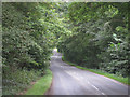
6
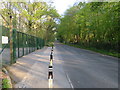
Horse Hill near Horley
View looking up the hill with the security fence of (and entrance to) the fracking site on the left.
Image: © Richard Rogerson
Taken: 16 Apr 2020
0.05 miles
7
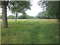
Footpath 414 Salfords & Sidlow
The final field before the road called Horse Hill is reached. The official route seems very lightly used here.
Image: © Robin Webster
Taken: 18 Jul 2010
0.06 miles

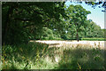
10
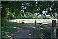
Paddocks by footpath 414 Salfords & Sidlow
The path follows the field edge on the left.
Image: © Robin Webster
Taken: 18 Jul 2010
0.14 miles