IMAGES TAKEN NEAR TO
Ranmore Common, DORKING, RH5 6SS
Introduction
This page details the photographs taken nearby to Ranmore Common, RH5 6SS by members of the Geograph project.
The Geograph project started in 2005 with the aim of publishing, organising and preserving representative images for every square kilometre of Great Britain, Ireland and the Isle of Man.

There are currently over 7.5m images from over14,400 individuals and you can help contribute to the project by visiting https://www.geograph.org.uk
Image Map
Images are licensed for reuse under creativecommons.org/licenses/by-sa/2.0
Notes
- Clicking on the map will re-center to the selected point.
- The higher the marker number, the further away the image location is from the centre of the postcode.
Image Listing (11 Images Found)
Images are licensed for reuse under creativecommons.org/licenses/by-sa/2.0
Image
Details
Distance
1
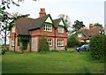
Dog Kennel Cottages at Dog Kennel Green
These four cottages have the appearance of being built by a local estate. They are located on a farm track off High Barn Road, which is also bridleway (Effingham 126) leading to Critten Lane. The OS map suggests the spelling should be "Dogkennel Green", the Royal Mail goes for "Dog Kennel Green".
Image: © Hugh Craddock
Taken: 5 May 2008
0.03 miles
2
Field near Dogkennel Green
Access road for St Teresa's School. Website - https://st-teresas.com/
Image: © James Emmans
Taken: 8 Dec 2021
0.13 miles
3
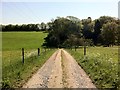
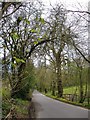
Drive to Haneys
Drive from High Barn Road to Haneys (out of sight down the valley to the right) also public footpath Effingham 125/Wootton 96 which continues through the wood opposite and onto Ranmore Common at Stoneyrock Lane.
Image: © Hugh Craddock
Taken: 25 May 2012
0.17 miles
4
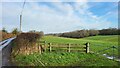
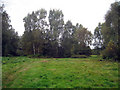
Downland by Critten Lane
The hedgerow-lined lane follows the bottom of a dry valley leading down from the North Downs ridgeline (right) towards Effingham (left). Grassy fields and patches of woodland are typical of this area.
Image: © Colin Smith
Taken: 17 Jun 2012
0.18 miles
5
Critten Lane: view south
View south and uphill towards the crest of the Downs west of Ranmore. Photo taken from close to the entrance to White Lodge.
Image: © Stefan Czapski
Taken: 13 Apr 2016
0.20 miles
6
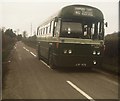
A London Country bus at Dogkennel Green
Taken in April 1975, this photo shows London Country RF122 (LYF 473) in High Barn Road, South of Dog Kennel Green. This vehicle, was one of a number of RFs that had a revised livery for Green Line routes into Central London. It is shown as working on route 412 although on this occasion, it was on a private tour of Surrey bus routes. This area is now served by Tuesday only route 533 (Ranmore - Ewhurst via Dorking, Ockley, Forest Green and Mayes Green), being operated by Carlone Buses.
Image: © David Hillas
Taken: 19 Apr 1975
0.22 miles
7
Dry Valley by Dogkennel Green
Chalk grassland in a valley leading down to the north from the North Downs ridgeway near Effingham.
Image: © Colin Smith
Taken: 17 Jun 2012
0.22 miles
8
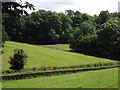
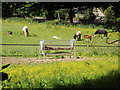
Downland by Dogkennel Green
Meadows in a downland dry valley south of Effingham.
Image: © Colin Smith
Taken: 17 Jun 2012
0.23 miles
9
Ranmore Common
National Trust land.
Image: © Oast House Archive
Taken: 3 Oct 2009
0.23 miles
10
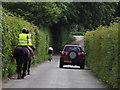
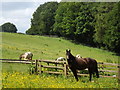
Jockeying for Space
Three different kinds of road user on Crittens Lane in the North Downs near Effingham.
Image: © Colin Smith
Taken: 17 Jun 2012
0.23 miles