IMAGES TAKEN NEAR TO
Guildford Road, DORKING, RH5 6RZ
Introduction
This page details the photographs taken nearby to Guildford Road, RH5 6RZ by members of the Geograph project.
The Geograph project started in 2005 with the aim of publishing, organising and preserving representative images for every square kilometre of Great Britain, Ireland and the Isle of Man.

There are currently over 7.5m images from over14,400 individuals and you can help contribute to the project by visiting https://www.geograph.org.uk
Image Map
Images are licensed for reuse under creativecommons.org/licenses/by-sa/2.0
Notes
- Clicking on the map will re-center to the selected point.
- The higher the marker number, the further away the image location is from the centre of the postcode.
Image Listing (68 Images Found)
Images are licensed for reuse under creativecommons.org/licenses/by-sa/2.0
Image
Details
Distance
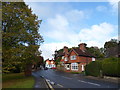
1
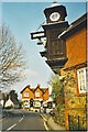
Abinger Hammer
The clock at Abinger Hammer is struck on the hour by "Jack the Hammer". The name Hammer comes from hammer ponds which were locally used in the medieval iron-making industry. The houses are typical Surrey tile-hung cottages, the one in the background is the Abinger Arms which ceased trading as a pub about 2012.
Image: © Colin Smith
Taken: Unknown
0.01 miles
2
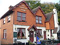
The Abinger Arms
Traditional village pub in Abinger Hammer, built in brick with a tile-hung frontage. It is on the main Guildford Road which runs E-W through the village but is now in different use as a cookery school.
Image: © Colin Smith
Taken: 7 Oct 2007
0.03 miles
3
The Abinger Arms
Former pub which closed in June 2012, just before this photo was taken. In the background can be seen Abinger Hammer clock, overhanging the road.
Image: © Ian Capper
Taken: 30 Jun 2012
0.04 miles
4
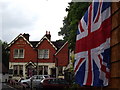
Diamond Jubilee at Abinger Hammer
Union Flags and bunting by the Abinger Arms on the main road through the village.
http://en.wikipedia.org/wiki/Abinger_Hammer
Image: © Colin Smith
Taken: 4 Jun 2012
0.04 miles
5
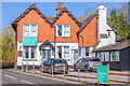
Former Abinger Arms
Former pub on Guildford Road, first licensed in 1840 but which closed in 2012, now housing a cookery school.
Image: © Ian Capper
Taken: 4 Apr 2023
0.04 miles
6
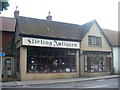
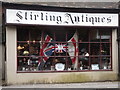
Stirling Antiques
Antiques shop on the main road running through Abinger Hammer village.
Image: © Colin Smith
Taken: 10 Jul 2011
0.05 miles
7
2016: a year on Geograph (Day 286)
Abinger Hammer
Image: © Basher Eyre
Taken: 12 Oct 2016
0.05 miles
8
Abinger Hammer in Spring
Looking west along the A25 to the clock.
Image: © Colin Smith
Taken: Unknown
0.05 miles
9
What Goes Round Comes Round
Coronation flags resurfacing for the Queen's Diamond Jubilee at Stirling Antiques, Abinger Hammer.
http://en.wikipedia.org/wiki/Abinger_Hammer
Image: © Colin Smith
Taken: 4 Jun 2012
0.06 miles
10
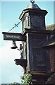
Jack the Blacksmith, Abinger Hammer
Travelling through the village of Abinger Hammer, the A25 passes below this distinctive clock. The figure is 'Jack the Blacksmith' which strikes the bell on the hour. The clock acknowledges the importance of the iron industry historically in the county of Surrey. The clock was presented in memory of the 1st Lord Farrer of Abinger Hall. He died in 1899.
Image: © Philip Halling
Taken: 27 Sep 1981
0.06 miles