IMAGES TAKEN NEAR TO
Sheephouse Lane, DORKING, RH5 6QL
Introduction
This page details the photographs taken nearby to Sheephouse Lane, RH5 6QL by members of the Geograph project.
The Geograph project started in 2005 with the aim of publishing, organising and preserving representative images for every square kilometre of Great Britain, Ireland and the Isle of Man.

There are currently over 7.5m images from over14,400 individuals and you can help contribute to the project by visiting https://www.geograph.org.uk
Image Map (Loading...)


Getting Data...Please wait
Leaflet Map data © OpenStreetMap
Images are licensed for reuse under creativecommons.org/licenses/by-sa/2.0
Notes
- Clicking on the map will re-center to the selected point.
- The higher the marker number, the further away the image location is from the centre of the postcode.
Image Listing (25 Images Found)
Images are licensed for reuse under creativecommons.org/licenses/by-sa/2.0
Image
Details
Distance
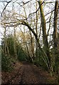
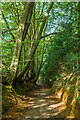
2
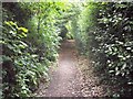
The Greensand Way in the valley of the Tilling Bourne: view north-west
The path here feels very enclosed, with a high bank on its east side and a narrow belt of woodland to the west - screening the Wotton Estate from public view.
Image: © Stefan Czapski
Taken: 5 Mar 2013
0.06 miles
3
Surrey Hills SE of Wotton
Sylvanus Wood on the left, with the Greensand Way running along on the right
Image: © Jonathan Hutchins
Taken: 10 Jun 2011
0.09 miles
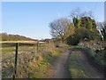
5
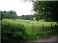
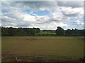
Fields west of Sheephouse Lane
looking west
Image: © Andrew Longton
Taken: 28 Sep 2005
0.11 miles
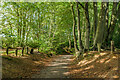
6
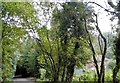
The Greensand Way in the valley of the Tilling Bourne
View southward. Along this stretch the right of way is flanked by a high bank to the east, while the valley of the Tilling Bourne to the west is largely hidden by a belt of woodland - as is so often the case on the Wotton Estate. Once the leaves are out the path must become quite tunnel-like. The trees leaning across the path are beeches.
Image: © Stefan Czapski
Taken: 5 Mar 2013
0.12 miles
7
Wolvens Lane
Byway between Coldharbour and Wotton.
Image: © Ian Capper
Taken: 11 Oct 2021
0.13 miles
8
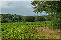
Off Wolvens Lane
A field off Wolvens Lane, a byway between Coldharbour and Wotton.
Image: © Ian Capper
Taken: 11 Oct 2021
0.13 miles
9
Wolvens Lane
Byway between Coldharbour and Wotton.
Image: © Ian Capper
Taken: 11 Oct 2021
0.13 miles
10
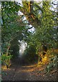
The 'Greensand Way' south of Tillingbourne Lodge
This stretch of farm track and its southerly continuation are now included in the 'Greensand Way' long-distance path. Not many paces ahead a stile and a finger-post mark the point where another right of way crosses, running NNE-SSW. The Greensand Way then leads downhill, in a sunken lane which at times is quite tunnel-like, with few glimpses of the surrounding terrain.
Image: © Stefan Czapski
Taken: 5 Mar 2013
0.14 miles