IMAGES TAKEN NEAR TO
Holmbury St. Mary, DORKING, RH5 6NS
Introduction
This page details the photographs taken nearby to RH5 6NS by members of the Geograph project.
The Geograph project started in 2005 with the aim of publishing, organising and preserving representative images for every square kilometre of Great Britain, Ireland and the Isle of Man.

There are currently over 7.5m images from over14,400 individuals and you can help contribute to the project by visiting https://www.geograph.org.uk
Image Map
Images are licensed for reuse under creativecommons.org/licenses/by-sa/2.0
Notes
- Clicking on the map will re-center to the selected point.
- The higher the marker number, the further away the image location is from the centre of the postcode.
Image Listing (49 Images Found)
Images are licensed for reuse under creativecommons.org/licenses/by-sa/2.0
Image
Details
Distance
1
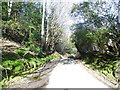
Holmbury Hill Road
This is typical of all the roads on the North Downs south of the A25, steep hills and woodland.
Image: © David Howard
Taken: 17 Apr 2016
0.02 miles
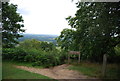
5
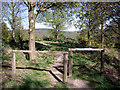
The Greensand Way at Holmbury Hill
View along the Greensand Way, where it runs along the southern edge of the Fort (Scheduled Monument) at the top of Holmbury Hill.
Image: © Tansy Forrest-Takano
Taken: 25 Apr 2009
0.09 miles
6
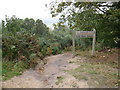
Bridleway warning on Holmbury Hill
Unusual warning sign on the bridleway due to a very steep slope!
Image: © don cload
Taken: 23 Sep 2009
0.09 miles
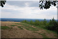
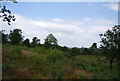
7
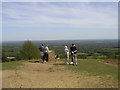
Viewing point, Holmbury Hill
One of the highest points on the Greensand Ridge.
Image: © N Chadwick
Taken: 3 Jul 2011
0.10 miles
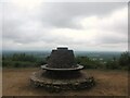
8
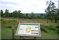
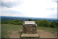
Information board, Holmbury Hill
Holmbury Camp is a small Iron Age hillfort. The defences consist of double ramparts and ditches to the north and west, triple scarping to the south and double scarping to the east; the north-west and south-west angles have been eroded by quarrying. Finds included pottery, flints, beehive quern stone fragments and sling pebbles.
Image: © N Chadwick
Taken: 3 Jul 2011
0.11 miles
9
Holmbury Camp
Holmbury Camp is a small Iron Age hillfort. The defences consist of double ramparts and ditches to the north and west, triple scarping to the south and double scarping to the east; the north-west and south-west angles have been eroded by quarrying. Finds included pottery, flints, beehive quern stone fragments and sling pebbles.
Image: © N Chadwick
Taken: 3 Jul 2011
0.11 miles