IMAGES TAKEN NEAR TO
Abinger Common, DORKING, RH5 6LS
Introduction
This page details the photographs taken nearby to RH5 6LS by members of the Geograph project.
The Geograph project started in 2005 with the aim of publishing, organising and preserving representative images for every square kilometre of Great Britain, Ireland and the Isle of Man.

There are currently over 7.5m images from over14,400 individuals and you can help contribute to the project by visiting https://www.geograph.org.uk
Image Map
Images are licensed for reuse under creativecommons.org/licenses/by-sa/2.0
Notes
- Clicking on the map will re-center to the selected point.
- The higher the marker number, the further away the image location is from the centre of the postcode.
Image Listing (11 Images Found)
Images are licensed for reuse under creativecommons.org/licenses/by-sa/2.0
Image
Details
Distance
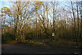
1
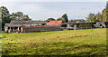
High Ashes Farm
Farm off Leith Hill Road.
Image: © Ian Capper
Taken: 11 Oct 2021
0.05 miles
2
The Greensand Way
Part of the Greensand Way from Leith Hill to Holmbury St Mary.
Image: © don cload
Taken: 2 Nov 2010
0.08 miles
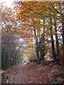
4
Bridleway east of High Ashes Farm
Image: © Christopher Hilton
Taken: 15 Jan 2012
0.09 miles
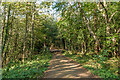
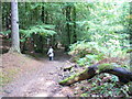
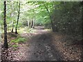
5
Track in the woods north of Leith Hill
The track seen starting here is a bridleway to the top of Leith Hill which avoids the busier areas further south.
Image: © Christopher Hilton
Taken: 15 Jan 2012
0.11 miles
6
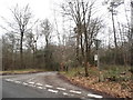
Sheephouse Lane at the junction of Leith Hill Lane
Image: © David Howard
Taken: 7 Feb 2016
0.11 miles
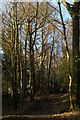
7
Highashes Hill
On the bridleway descending through mixed woodland to the Leylands Road.
Image: © Colin Smith
Taken: 5 Oct 2007
0.14 miles
8
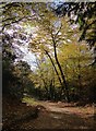
Track through woodland on the slopes of Leith Hill
Image: © Stefan Czapski
Taken: 5 Nov 2017
0.17 miles
10
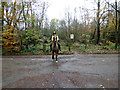
Surrey Hills: End of the bridleway
The rider had just emerged from the bridleway opposite onto the metalled surface of Leith Hill Road
Image: © Dr Neil Clifton
Taken: 16 Nov 2014
0.18 miles