IMAGES TAKEN NEAR TO
Coldharbour, DORKING, RH5 6HD
Introduction
This page details the photographs taken nearby to RH5 6HD by members of the Geograph project.
The Geograph project started in 2005 with the aim of publishing, organising and preserving representative images for every square kilometre of Great Britain, Ireland and the Isle of Man.

There are currently over 7.5m images from over14,400 individuals and you can help contribute to the project by visiting https://www.geograph.org.uk
Image Map
Images are licensed for reuse under creativecommons.org/licenses/by-sa/2.0
Notes
- Clicking on the map will re-center to the selected point.
- The higher the marker number, the further away the image location is from the centre of the postcode.
Image Listing (107 Images Found)
Images are licensed for reuse under creativecommons.org/licenses/by-sa/2.0
Image
Details
Distance
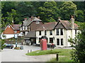
1
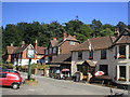
Coldharbour Village
The highest (and possibly most remote) village in South East England, Coldharbour is reached through miles of leafy country lanes from Dorking. The village pub, The Plough, can be seen in the picture.
Image: © Richard Slessor
Taken: 2 Aug 2003
0.00 miles
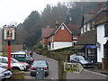
2
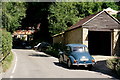
Coldharbour
Close to the centre of the village, with a Morris Minor 1000 parked up.
Image: © Peter Trimming
Taken: 7 Aug 2020
0.00 miles
5
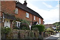
Coldharbour, Surrey
A view of the centre of the village, taken from the steep track which runs up to Leith Hill. The telephone box in the foreground is possibly at a higher altitude than any other in the south-east of England.
Image: © Peter Trimming
Taken: 16 Jul 2009
0.01 miles
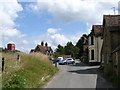
6
Coldharbour Village
The centre of this village on Leith Hill is busy with cyclists and motorists who come to visit The Plough Inn and to stroll up nearby Leith Hill, Surrey's highest point.
Image: © Colin Smith
Taken: 20 Feb 2011
0.01 miles
8
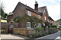
Coldharbour, Surrey
Looking along Abinger Lane, to the north-east. A conventional village might have a green at this location, but Abinger Road runs near the top of the hill, and the housing straggles along the road, generally just to one side.
Image: © Peter Trimming
Taken: 16 Jul 2009
0.01 miles
9
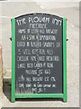
Sign at The Plough, Coldharbour, Surrey
The sign says it all ...... except, perhaps, that it is the most expensive pub in Coldharbour! £10+ for a pint and a sandwich. I had forgotten that when I brought the cycling club here, in 2001, several people complained about the prices.
Image: © Peter Trimming
Taken: 16 Jul 2009
0.02 miles
10
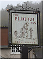
Plough Inn sign, Coldharbour
A new sign since the last one from five years ago.
Image: © Robert Eva
Taken: 24 Oct 2017
0.02 miles