IMAGES TAKEN NEAR TO
Swanworth Lane, DORKING, RH5 6ER
Introduction
This page details the photographs taken nearby to Swanworth Lane, RH5 6ER by members of the Geograph project.
The Geograph project started in 2005 with the aim of publishing, organising and preserving representative images for every square kilometre of Great Britain, Ireland and the Isle of Man.

There are currently over 7.5m images from over14,400 individuals and you can help contribute to the project by visiting https://www.geograph.org.uk
Image Map
Images are licensed for reuse under creativecommons.org/licenses/by-sa/2.0
Notes
- Clicking on the map will re-center to the selected point.
- The higher the marker number, the further away the image location is from the centre of the postcode.
Image Listing (45 Images Found)
Images are licensed for reuse under creativecommons.org/licenses/by-sa/2.0
Image
Details
Distance
1
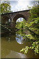
Viaduct over River Mole
Viaduct carrying the Dorking to Leatherhead railway over the River Mole south of Mickleham Tunnel.
Image: © Ian Capper
Taken: 6 May 2013
0.09 miles
3
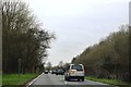
A24 in the Mole Gap
At the expense of some sharp bends, the road manages to stay on the east side of the River Mole until the bridge near Dorking. This carriageway has been reduced to one lane because of these bends and the several side turnings.
Image: © Robin Webster
Taken: 1 Nov 2011
0.10 miles
4
Mickleham Tunnel and Norbury View
Looking along the Dorking to Leatherhead railway from Swanworth Lane level crossing (now a footpath only crossing), with the south portal of Mickleham Tunnel in the left background (see Image) and Image) and Norbury View on the right (see Image).
Image: © Ian Capper
Taken: 6 May 2013
0.11 miles
5
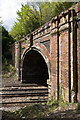
South portal, Mickleham Tunnel
The south portal of Mickleham Tunnel on the Dorking to Leatherhead railway. Opened in 1867, the tunnel is 524 yards long and goes under a spur of the North Downs in Norbury Park. The owner of Norbury Park at the time, Thomas Grissell, imposed various conditions on the railway, and this included the special architectural treatment of the portal here.
Image: © Ian Capper
Taken: 6 May 2013
0.11 miles
6
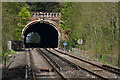
Mickleham Tunnel
A telephoto view from Swanworth Lane level crossing (now a footpath only crossing) of Mickleham Tunnel on the Dorking to Leatherhead railway. For a closer view of the south portal of the tunnel, as seen here, see Image
Image: © Ian Capper
Taken: 6 May 2013
0.11 miles
7
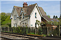
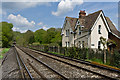
Norbury View
Pair of semi-detached cottages alongside where Swanworth Lane crosses the Leatherhead to Dorking Railway (now only a footpath level crossing)
Image: © Ian Capper
Taken: 6 May 2013
0.11 miles
8
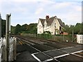
House at a Rail Crossing
A footpath crosses the tracks just here. The house looks like it might have been a crossing keepers residence at one time?
Image: © Des Blenkinsopp
Taken: 18 Sep 2014
0.11 miles
9
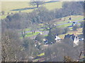
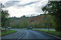
Swanworth Farm
Dual carriageway, farm and railway line all sharing the narrow corridor of the Mole Gap through the North Downs. Taken from the viewpoint in Norbury Park.
Image: © Colin Smith
Taken: 10 Feb 2008
0.12 miles
10
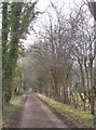
Swanworth Lane, Mickleham
Before the coming of the A24 Mickleham by-pass, in the mid 1930's, this lane must have been the route from Swanworth Farm to the old London road, joining it near Mickleham church. The view here is west, towards the A24 dual-carriageway, just visible about 150m ahead. Swanworth Farm lies on the far side of the main road, so that this stretch of Swanworth Lane has become a backwater - and a pleasant walking route. Visible between the trees on the right are the playing fields of Boxhill School.
For the view eastward, toward the village, from about the same spot, see Derek Harper's Image - taken about a year earlier.
Image: © Stefan Czapski
Taken: 20 Feb 2012
0.12 miles