IMAGES TAKEN NEAR TO
Dell Close, DORKING, RH5 6EE
Introduction
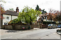
This page details the photographs taken nearby to Dell Close, RH5 6EE by members of the Geograph project.
The Geograph project started in 2005 with the aim of publishing, organising and preserving representative images for every square kilometre of Great Britain, Ireland and the Isle of Man.

There are currently over 7.5m images from over14,400 individuals and you can help contribute to the project by visiting https://www.geograph.org.uk
Image Map
Images are licensed for reuse under creativecommons.org/licenses/by-sa/2.0
Notes
- Clicking on the map will re-center to the selected point.
- The higher the marker number, the further away the image location is from the centre of the postcode.
Image Listing (189 Images Found)
Images are licensed for reuse under creativecommons.org/licenses/by-sa/2.0
Image
Details
Distance
1
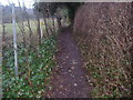
Footpath between Dell Close and School Lane, Mickleham
You can just see the North Downs on the left
Image: © David Howard
Taken: 8 Feb 2010
0.01 miles
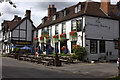
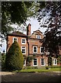
3
Burmester House
18th Century grade II listed at the junction of Dell Close and Old London Road - see http://www.historicengland.org.uk/listing/the-list/list-entry/1228743.
Image: © Ian Capper
Taken: 6 May 2013
0.03 miles
4
Burmester House
18th Century grade II listed at the junction of Dell Close and Old London Road - see http://www.historicengland.org.uk/listing/the-list/list-entry/1228743.
Image: © Ian Capper
Taken: 6 May 2013
0.03 miles
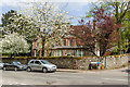
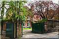
5
Coach House and The Old Cottage
The Old Cottage (in the background) is a grade II listed house dating from 1725 - see http://www.historicengland.org.uk/listing/the-list/list-entry/1378080.
Image: © Ian Capper
Taken: 6 May 2013
0.04 miles
6
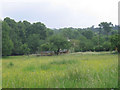
Meadow in Mickleham
This small meadow (about 1 hectare) is enclosed by public footpaths on all four sides.
Image: © Stephen Craven
Taken: 11 Jun 2007
0.04 miles
8
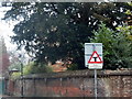
Unusual T junction sign on Old London Road
Besides T junction signs no longer being made normally, this is the only one I've seen with a major (thicker) road, although it's actually the wrong way round.
Image: © David Howard
Taken: 16 Nov 2014
0.05 miles
9
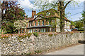
The Old House, Mickleham
I believe the style here is what is known as Artisan Mannerism. The term is much used, by people like Sir Niklaus Pevsner and Sir John Summerson, but tends to go undefined. Characteristic features (as I understand it) include shaped gables (and other Dutch-inspired features), thick string courses, and (typically) red brickwork.
Ian Nairn, writing in the Surrey volume of Pevsner's 'The Buildings of England', dates the building to 1636, but suggests that its character was compromised in the following century, when (amongst other changes) the windows were enlarged.
Comments welcome!
Image: © Stefan Czapski
Taken: 18 May 2020
0.05 miles
10
Old House
Grade II* listed house dating from 1636 - see http://www.historicengland.org.uk/listing/the-list/list-entry/1028837.
Image: © Ian Capper
Taken: 6 May 2013
0.05 miles