IMAGES TAKEN NEAR TO
London Road, DORKING, RH5 6DB
Introduction
This page details the photographs taken nearby to London Road, RH5 6DB by members of the Geograph project.
The Geograph project started in 2005 with the aim of publishing, organising and preserving representative images for every square kilometre of Great Britain, Ireland and the Isle of Man.

There are currently over 7.5m images from over14,400 individuals and you can help contribute to the project by visiting https://www.geograph.org.uk
Image Map
Images are licensed for reuse under creativecommons.org/licenses/by-sa/2.0
Notes
- Clicking on the map will re-center to the selected point.
- The higher the marker number, the further away the image location is from the centre of the postcode.
Image Listing (161 Images Found)
Images are licensed for reuse under creativecommons.org/licenses/by-sa/2.0
Image
Details
Distance
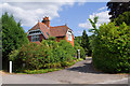
1
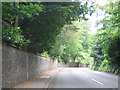
The old road through Mickleham
The old course of the A24 through Mickleham village, now fairly quiet as it has been bypassed. The tall wall runs alongside the road for several hundred metres.
Image: © Stephen Craven
Taken: 11 Jun 2007
0.06 miles
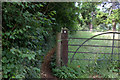
4
Wooden Gateway
Unique wooden gateway on the side of St Michael's Churchyard
Image: © Martyn Davies
Taken: 28 Dec 2007
0.13 miles
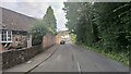
5
Church Lodge
Lodge to Juniper Hill, once home, among others, to Theodore Bryant, founder of Bryant and May, the match manufacturer.
Image: © Ian Capper
Taken: 5 Jul 2010
0.14 miles
8
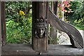
Mickleham, St. Michael's Church: Fine carving in the lych gate
Image: © Michael Garlick
Taken: 31 Mar 2019
0.15 miles
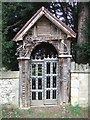
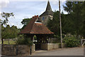
9

Lychgate, St Michael's Church, Mickleham
Believed to be late 19th century. It is grade II listed, while the church itself is grade II* listed - for listing particulars see www.historicengland.org.uk/listing/the-list/list-entry/1033378 and www.historicengland.org.uk/listing/the-list/list-entry/1028835 respectively.
Image: © Ian Capper
Taken: 5 Jul 2010
0.15 miles
10
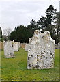
The churchyard at Mickleham
The south side of the churchyard, looking east. The weathered tombstones nearest the camera are of 18th century date. I can't identify the stone they are made of, and it cannot be local. Whatever it is, it attracts lichens, unlike the more yellowish stones seen in the background.
Image: © Stefan Czapski
Taken: 14 Feb 2012
0.15 miles