IMAGES TAKEN NEAR TO
London Road, DORKING, RH5 6BZ
Introduction
This page details the photographs taken nearby to London Road, RH5 6BZ by members of the Geograph project.
The Geograph project started in 2005 with the aim of publishing, organising and preserving representative images for every square kilometre of Great Britain, Ireland and the Isle of Man.

There are currently over 7.5m images from over14,400 individuals and you can help contribute to the project by visiting https://www.geograph.org.uk
Image Map
Images are licensed for reuse under creativecommons.org/licenses/by-sa/2.0
Notes
- Clicking on the map will re-center to the selected point.
- The higher the marker number, the further away the image location is from the centre of the postcode.
Image Listing (44 Images Found)
Images are licensed for reuse under creativecommons.org/licenses/by-sa/2.0
Image
Details
Distance
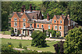
1

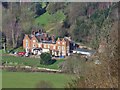
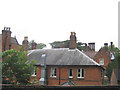
House on Headley Lane
A view of a residential house, part of the Juniper Hall Field Study Centre, situated on Headley Lane, east of Mickleham in Surrey.
Image: © John P Reeves
Taken: 30 May 2020
0.01 miles
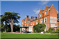
3
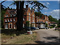
Juniper Hall Field Studies Centre
A view of this imposing 18th century house from the driveway. Particularly of note are the ornamental chimney stacks which are works of art in their own right.
Image: © Alan Hunt
Taken: 25 Jul 2010
0.02 miles
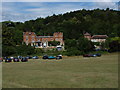
4
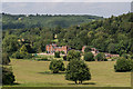
Juniper Hall
A field centre near Mickleham and Box Hill, used for geographic and scientific studies.
Image: © Colin Smith
Taken: 19 Feb 2016
0.02 miles
5
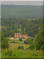
Juniper Hall
Built in the late 18th century on the site of a former pub, the Royal Oak, and much altered in the 1880s, this building is now a study centre run by the Field Studies Council. In the early 1790s it was home to a number of eminent émigrés from the French Revolution.
It is grade II listed - for listing particulars see www.historicengland.org.uk/listing/the-list/list-entry/1228450.
Just below the skyline is Norbury Park, a grade II* mansion built in 1774 by William Locke. For listing particulars see www.historicengland.org.uk/listing/the-list/list-entry/1228829.
Image: © Ian Capper
Taken: 21 Jun 2014
0.02 miles
6
Juniper Hall - building detail
A close up of part of Image showing the tall chimneys.
Image: © Stephen Craven
Taken: 11 Jun 2007
0.02 miles
7
Juniper Hall Field Studies Centre
This 18th century house in Mickleham has been used as a field study centre since 1947. During the build up to the Normandy landings it was occupied by the Canadian Army. At the time of the French revolution it was leased by French noblemen who had fled to England. The event taking place in the grounds is the biennial Garden Festival held by the Surrey Branch of Butterfly Conservation.
Image: © Alan Hunt
Taken: 25 Jul 2010
0.02 miles
8
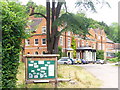
Juniper Hall Field Centre
Historic mansion near Mickleham, now used as a field centre for geographers.
http://www.field-studies-council.org/juniperhall/
Image: © Colin Smith
Taken: 10 Jul 2009
0.03 miles
9
Juniper Hall
Built in the late 18th century on the site of a former pub, the Royal Oak, and much altered in the 1880s, this building is now a study centre run by the Field Studies Council. In the early 1790s it was home to a number of eminent émigrés from the French Revolution.
It is grade II listed - for listing particulars see www.historicengland.org.uk/listing/the-list/list-entry/1228450.
Image: © Ian Capper
Taken: 30 Aug 2010
0.03 miles
10
Juniper Hall
Built in the late 18th century on the site of a former pub, the Royal Oak, and much altered in the 1880s, this building is now a study centre run by the Field Studies Council. In the early 1790s it was home to a number of eminent émigrés from the French Revolution.
It is grade II listed - for listing particulars see www.historicengland.org.uk/listing/the-list/list-entry/1228450.
Image: © Ian Capper
Taken: 21 Jun 2014
0.03 miles