IMAGES TAKEN NEAR TO
Chapel Lane, DORKING, RH5 6AY
Introduction
This page details the photographs taken nearby to Chapel Lane, RH5 6AY by members of the Geograph project.
The Geograph project started in 2005 with the aim of publishing, organising and preserving representative images for every square kilometre of Great Britain, Ireland and the Isle of Man.

There are currently over 7.5m images from over14,400 individuals and you can help contribute to the project by visiting https://www.geograph.org.uk
Image Map
Images are licensed for reuse under creativecommons.org/licenses/by-sa/2.0
Notes
- Clicking on the map will re-center to the selected point.
- The higher the marker number, the further away the image location is from the centre of the postcode.
Image Listing (35 Images Found)
Images are licensed for reuse under creativecommons.org/licenses/by-sa/2.0
Image
Details
Distance
1
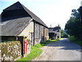
Chapel Lane
Rural lane leading past a black wooden barn and downhill into Westhumble, a Mole Gap hamlet.
Image: © Colin Smith
Taken: 20 Sep 2008
0.01 miles
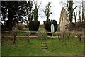
2
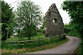
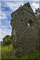
Westhumble Chapel
Scheduled Monument, cared for by the National Trust since 1937. The chapel was founded at the end of the twelfth century and desecrated three centuries later.
Image: © Peter Trimming
Taken: 3 Jun 2022
0.02 miles
3
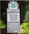
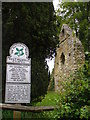
Westhumble Chapel National Trust
The National Trust notice at Westhumble Chapel. On the route of London Green Belt Way. To view chapel ruin see https://www.geograph.org.uk/photo/6432269
Image: © Sean Davis
Taken: 28 Jun 2007
0.02 miles
4
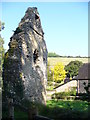
Westhumble Chapel
Ruins of 12th century Westhumble Chapel. Now cared for by the National Trust and on the route of London Green Belt Way. To read National Trust notice see https://www.geograph.org.uk/photo/6432263
Image: © Sean Davis
Taken: 28 Jun 2007
0.02 miles
6
Westhumble Chapel
Only one wall of the ancient 12th century chapel remains standing.
Image: © Colin Smith
Taken: 22 May 2011
0.02 miles
7
Ruined Westhumble Chapel
This flint wall is practically all that remains of the 12th century chapel which lasted about three centuries.
Image: © Colin Smith
Taken: 20 Sep 2008
0.02 miles
8
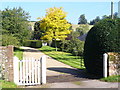
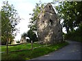
Chapel Farm Gateway
Downland farm in Westhumble with cattle grid and tree in colourful early autumn foliage.
Image: © Colin Smith
Taken: 20 Sep 2008
0.02 miles
9
Westhumble Chapel
Only the west gable and parts of the east end remain of the oldest building in Westhumble. The chapel is thought to have been built during the late twelfth or early thirteenth century for the use of villagers, particularly when floods prevented them from reaching the Parish Church in Mickleham. It was probably abandoned as a place of worship during the mid-sixteenth century, although part of it was probably used as a farm outbuilding for some time.
Image: © Rob Noble
Taken: 29 Mar 2013
0.02 miles
10
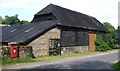
Barn at Chapel Farm
Old barn and post box at Chapel Farm, Westhumble. This is on the route of London Green Belt Way.
Image: © Sean Davis
Taken: 28 Jun 2007
0.03 miles