IMAGES TAKEN NEAR TO
Walliswood, DORKING, RH5 5QH
Introduction
This page details the photographs taken nearby to RH5 5QH by members of the Geograph project.
The Geograph project started in 2005 with the aim of publishing, organising and preserving representative images for every square kilometre of Great Britain, Ireland and the Isle of Man.

There are currently over 7.5m images from over14,400 individuals and you can help contribute to the project by visiting https://www.geograph.org.uk
Image Map
Images are licensed for reuse under creativecommons.org/licenses/by-sa/2.0
Notes
- Clicking on the map will re-center to the selected point.
- The higher the marker number, the further away the image location is from the centre of the postcode.
Image Listing (4 Images Found)
Images are licensed for reuse under creativecommons.org/licenses/by-sa/2.0
Image
Details
Distance
1
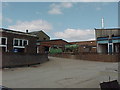
Smokejacks (now Ewhurst) Brickworks, Oakwoodhill
View from the engineering department of the brickworks, opened in the 1920s, and now under Austrian Management.
Image: © James 'Dan' Hall
Taken: 6 Mar 2005
0.16 miles
2
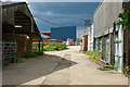
Through the farmyard to the brickworks
The farmyard is directly connected to the brickworks area, so is presumably part of the same concern. Possibly what farming activity is retained (and there seems little) is to do with the management of the property reserved for future clay digging.
Image: © Robin Webster
Taken: 1 Aug 2010
0.17 miles