IMAGES TAKEN NEAR TO
Honeywood Lane, DORKING, RH5 5QA
Introduction
This page details the photographs taken nearby to Honeywood Lane, RH5 5QA by members of the Geograph project.
The Geograph project started in 2005 with the aim of publishing, organising and preserving representative images for every square kilometre of Great Britain, Ireland and the Isle of Man.

There are currently over 7.5m images from over14,400 individuals and you can help contribute to the project by visiting https://www.geograph.org.uk
Image Map
Images are licensed for reuse under creativecommons.org/licenses/by-sa/2.0
Notes
- Clicking on the map will re-center to the selected point.
- The higher the marker number, the further away the image location is from the centre of the postcode.
Image Listing (39 Images Found)
Images are licensed for reuse under creativecommons.org/licenses/by-sa/2.0
Image
Details
Distance
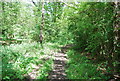
4
Monks Lane and Honey Lane
Both are public bridleways from this point, but Monks Lane to the left is also the road to Monks Farm, private from the vague gateway onwards.
Image: © Robin Webster
Taken: 1 Aug 2010
0.06 miles
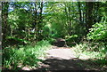
5
Entrance to Honeybush Farm
Near the bridleway junction of Monks Lane and Honey Lane, both of which are the bridleways.
Image: © Dave Spicer
Taken: 4 Dec 2011
0.06 miles
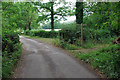
7
Monks Lane going north
This is in West Sussex.
Image: © Shazz
Taken: 21 Jan 2016
0.08 miles