IMAGES TAKEN NEAR TO
Hogspudding Lane, DORKING, RH5 5DS
Introduction
This page details the photographs taken nearby to Hogspudding Lane, RH5 5DS by members of the Geograph project.
The Geograph project started in 2005 with the aim of publishing, organising and preserving representative images for every square kilometre of Great Britain, Ireland and the Isle of Man.

There are currently over 7.5m images from over14,400 individuals and you can help contribute to the project by visiting https://www.geograph.org.uk
Image Map
Images are licensed for reuse under creativecommons.org/licenses/by-sa/2.0
Notes
- Clicking on the map will re-center to the selected point.
- The higher the marker number, the further away the image location is from the centre of the postcode.
Image Listing (17 Images Found)
Images are licensed for reuse under creativecommons.org/licenses/by-sa/2.0
Image
Details
Distance
2
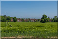
Towards Mulberry Place
Looking across a field towards Mulberry Place, a development dating from 2002-3 on the site of a former brickworks. Although officially called Mulberry Place in post office listings, it is marked as Mullberry Place on the large scale Ordnance Survey map. Locally it is known as "The Mulberries".
Image: © Ian Capper
Taken: 20 May 2018
0.08 miles
3
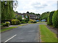
Houses in Mulberry Place, Newdigate
Built on the site of Newdigate Brickworks.
Image: © Robin Webster
Taken: 30 Jun 2010
0.10 miles
4
Hogspudding Lane
The name is a real classic - some other favourites of mine are Powder Monkey Lane (Upnor), Squeezeguts Alley (Truro) and Tinderbox Alley (Mortlake). I suspect that many of the most memorable English street names commemorate vanished pubs or inns - but whether that applies in this case, I can't say.
Image: © Stefan Czapski
Taken: 7 Oct 2013
0.17 miles
6
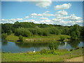
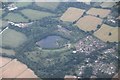
Newdigate Brickworks Nature Reserve
Newdigate Brickworks opened in c.1928 and was a successful business for many years. The works closed during the Second World War and much of the site became derelict, but handmade bricks were made here on a smaller scale after the war, the trade lasting until 1974. The site then lay derelict until 2004, when a housing development was built on the old factory site and the four lakes left over from quarrying became a public nature reserve managed by the Surrey Wildlife Trust. The reserve covers 43 acres of lake, grassland and woodland near the centre of this grid-square.
Image: © Dan Gregory
Taken: 14 Aug 2008
0.19 miles
7
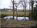
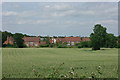
Pond near Hatchetts
East of Newdigate, looking across a field to a modern housing development which has some homes designed to look like old Wealden hall houses.
Image: © Colin Smith
Taken: 13 Mar 2010
0.19 miles
8
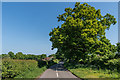
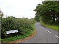
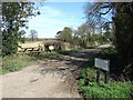
Hogspudding Lane
Lane on the eastern edge of Newdigate
Image: © Ian Capper
Taken: 20 May 2018
0.19 miles
10
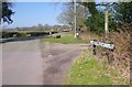
Junction of road with lanes and public footpath
See also http://www.geograph.org.uk/photo/147771.
Image: © Shazz
Taken: 13 Mar 2016
0.21 miles