IMAGES TAKEN NEAR TO
Paddock Grove, DORKING, RH5 4QL
Introduction
This page details the photographs taken nearby to Paddock Grove, RH5 4QL by members of the Geograph project.
The Geograph project started in 2005 with the aim of publishing, organising and preserving representative images for every square kilometre of Great Britain, Ireland and the Isle of Man.

There are currently over 7.5m images from over14,400 individuals and you can help contribute to the project by visiting https://www.geograph.org.uk
Image Map
Images are licensed for reuse under creativecommons.org/licenses/by-sa/2.0
Notes
- Clicking on the map will re-center to the selected point.
- The higher the marker number, the further away the image location is from the centre of the postcode.
Image Listing (46 Images Found)
Images are licensed for reuse under creativecommons.org/licenses/by-sa/2.0
Image
Details
Distance
1
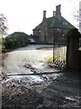
"Dutch Style" House
Perhaps a Edwin Lutyens design?
Image: © Martyn Davies
Taken: 22 Jan 2006
0.04 miles
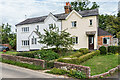
2
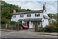
Starmount Cottages
Semi-detached pair of Victorian houses on Old Horsham Road.
Image: © Ian Capper
Taken: 4 Sep 2020
0.04 miles
3
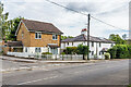
17 Paddock Grove and White Hart Cottages
Buildings on Old Horsham Road. 17 Paddock Grove, on the left, is part of a c1970s/80s development and White Hart Cottages are a pair of early 19th Century semi-detached cottages.
Image: © Ian Capper
Taken: 4 Sep 2020
0.04 miles
4
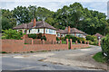
Bregsells Drive
Pair of c1960s houses in Bregsells Drive, at the start of Bregsells Lane, Tumblewood on the left and Alpenrose beyond.
Image: © Ian Capper
Taken: 4 Sep 2020
0.05 miles
5
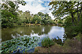
Beare Green Pond
Pond in a former clay pit serving a brick and tiles works formerly on the site until the late 19th Century.
Image: © Ian Capper
Taken: 4 Sep 2020
0.06 miles
6
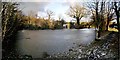
No swimming today
Ice on Image kept the waterfowl out of the water.
Image: © Andy Potter
Taken: 5 Jan 2009
0.07 miles
7
Starmount and Box Cottage
Pair of semi-detached houses on Old Horsham Road, built in 1867.
Image: © Ian Capper
Taken: 4 Sep 2020
0.07 miles
8
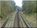
Railway north from Holmwood station
Looking from the Old Horsham Road bridge to the A24 Horsham Road bridge. Milepost 27 on the right - the datum seems to be Waterloo, although no trains are routed from there now.
Image: © Robin Webster
Taken: 15 Mar 2011
0.07 miles
9
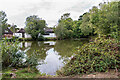
Beare Green Pond
Pond in a former clay pit serving a brick and tiles works formerly on the site until the late 19th Century. In the background is the village hall.
Image: © Ian Capper
Taken: 4 Sep 2020
0.08 miles
10
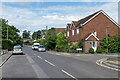
Old Horsham Road
The main road through Beare Green, bypassed in the early 1970s by the current A24. On the right is Greenfields Place, a cul-de-sac built on the site of the White Hart Inn following its closure in 1991.
Image: © Ian Capper
Taken: 4 Sep 2020
0.08 miles