IMAGES TAKEN NEAR TO
Beare Green Road, DORKING, RH5 4PY
Introduction
This page details the photographs taken nearby to Beare Green Road, RH5 4PY by members of the Geograph project.
The Geograph project started in 2005 with the aim of publishing, organising and preserving representative images for every square kilometre of Great Britain, Ireland and the Isle of Man.

There are currently over 7.5m images from over14,400 individuals and you can help contribute to the project by visiting https://www.geograph.org.uk
Image Map
Images are licensed for reuse under creativecommons.org/licenses/by-sa/2.0
Notes
- Clicking on the map will re-center to the selected point.
- The higher the marker number, the further away the image location is from the centre of the postcode.
Image Listing (16 Images Found)
Images are licensed for reuse under creativecommons.org/licenses/by-sa/2.0
Image
Details
Distance
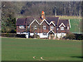
2
Buckinghill Farm House
Late 16th or 17th Century farmhouse. Grade II listed - see www.historicengland.org.uk/listing/the-list/list-entry/1378167. The track in the foreground is on the route of the Roman route from London to Chichester, Stane Street.
Image: © Ian Capper
Taken: 12 May 2018
0.04 miles
3
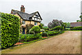
Buckinghill Farm House
Late 16th or 17th Century farmhouse. Grade II listed - see www.historicengland.org.uk/listing/the-list/list-entry/1378167. The track in the foreground is on the route of the Roman route from London to Chichester, Stane Street.
Image: © Ian Capper
Taken: 12 May 2018
0.04 miles
4
Buckinghill Farm
Grassy footpath leading past an attractive farmhouse building in the Weald south of Coldharbour.
Image: © Colin Smith
Taken: 20 Feb 2011
0.08 miles
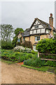
5
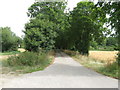
Footpath and driveway to Buckinghill Farm
Image: © Dave Spicer
Taken: 11 Aug 2013
0.08 miles
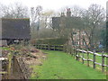
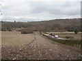
7

The A29 turns away from the Roman line
The Roman Stane Street continues at first as a private drive and public footpath. Only fragments of the onwards route over hilly terrain are now public rights-of-way until rejoined by the A29 which takes a longer but easier way round.
Image: © Robin Webster
Taken: 25 Nov 2022
0.10 miles
8
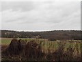
West of Buckinghill Farm
Field west of Buckinghill Farm, with part of Nutfold Copse on the left.
Image: © Ian Capper
Taken: 12 May 2018
0.11 miles
9
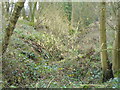
Holms Gill
Difficult to see but there is an incised and meandering stream here. It is a headwater of the North River.
Image: © Colin Smith
Taken: 20 Feb 2011
0.13 miles
10
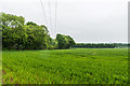
The A29 leaves the line of the Roman road
The A29 bends sharply to the right whilst Stane Street continued along the line of the modern avenue leading to Buckinghill Farm.
Image: © Andy Potter
Taken: 11 Feb 2009
0.13 miles