IMAGES TAKEN NEAR TO
Lodge Lane, DORKING, RH5 4NY
Introduction
This page details the photographs taken nearby to Lodge Lane, RH5 4NY by members of the Geograph project.
The Geograph project started in 2005 with the aim of publishing, organising and preserving representative images for every square kilometre of Great Britain, Ireland and the Isle of Man.

There are currently over 7.5m images from over14,400 individuals and you can help contribute to the project by visiting https://www.geograph.org.uk
Image Map
Images are licensed for reuse under creativecommons.org/licenses/by-sa/2.0
Notes
- Clicking on the map will re-center to the selected point.
- The higher the marker number, the further away the image location is from the centre of the postcode.
Image Listing (7 Images Found)
Images are licensed for reuse under creativecommons.org/licenses/by-sa/2.0
Image
Details
Distance
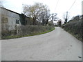
1
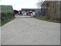
Lodge Farm, South Holmwood
The final part of this road is not on Streetview
Image: © David Howard
Taken: 27 Nov 2016
0.03 miles
3
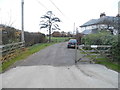
Ford farm house, South Holmwood
I was trying to get into the adjacent square TQ1945 but all approaches and land are private.
Image: © David Howard
Taken: 27 Nov 2016
0.04 miles
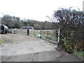
5

Closed foot crossing near Lodge Farm
With safety in view, this foot crossing of the Dorking to Horsham railway has now been permanently closed. Incidentally there is no right of way on the western side by Lodge Farm.
Image: © Dr Neil Clifton
Taken: 20 May 2015
0.06 miles
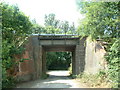
6

Towards Railway Cottages
Looking down the track that leads from Shellwood Manor to Lodge Lane. Railway Cottages is the white house in the distance, and is situated by where the track crosses the Dorking to Horsham railway.
Image: © Ian Capper
Taken: 30 May 2010
0.08 miles