IMAGES TAKEN NEAR TO
Guildford Road, DORKING, RH4 3PZ
Introduction
This page details the photographs taken nearby to Guildford Road, RH4 3PZ by members of the Geograph project.
The Geograph project started in 2005 with the aim of publishing, organising and preserving representative images for every square kilometre of Great Britain, Ireland and the Isle of Man.

There are currently over 7.5m images from over14,400 individuals and you can help contribute to the project by visiting https://www.geograph.org.uk
Image Map
Images are licensed for reuse under creativecommons.org/licenses/by-sa/2.0
Notes
- Clicking on the map will re-center to the selected point.
- The higher the marker number, the further away the image location is from the centre of the postcode.
Image Listing (63 Images Found)
Images are licensed for reuse under creativecommons.org/licenses/by-sa/2.0
Image
Details
Distance
1
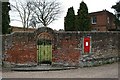
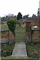
Old Bury Hill Stables: garden entrance and letter box
Garden entrance to Old Bury Hill Stables from Milton Street, just south of the junction with the Guildford Road (A25).
Image: © Hugh Craddock
Taken: 9 Mar 2010
0.11 miles
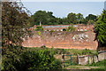
2
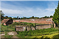
Wall, Old Bury Hill Gardens
Former walled garden of Bury Hill. Bury Hill was a large mansion built by James Walter in 1753. In 1805 (or 1812 or 1815, depending on source) the house and a large part of the estate was bought by Robert Barclay, a Southwark Brewer, whose family remained there for almost 150 years.
The house was occupied by the military in the Second World War. After the war it was converted to flats, but whilst this was happening, the centre part was destroyed by fire, although the outer parts survived and remain in residential use.
The gardens of which this the wall, along with the former orangery/stable block which forms the rear of the garden (not visible in this photo), date from the 18th Century and are grade II and grade II* listed respectively - see https://www.historicengland.org.uk/listing/the-list/list-entry/1229032 and https://www.historicengland.org.uk/listing/the-list/list-entry/1228824.
Image: © Ian Capper
Taken: 24 Sep 2016
0.12 miles

4
Wall, Old Bury Hill Gardens
Former walled garden of Bury Hill. Bury Hill was a large mansion built by James Walter in 1753. In 1805 (or 1812 or 1815, depending on source) the house and a large part of the estate was bought by Robert Barclay, a Southwark Brewer, whose family remained there for almost 150 years.
The house was occupied by the military in the Second World War. After the war it was converted to flats, but whilst this was happening, the centre part was destroyed by fire, although the outer parts survived and remain in residential use.
The gardens of which this the wall, along with the former orangery/stable block which forms the rear of the garden (not visible in this photo), date from the 18th Century and are grade II and grade II* listed respectively - see https://www.historicengland.org.uk/listing/the-list/list-entry/1229032 and https://www.historicengland.org.uk/listing/the-list/list-entry/1228824.
Image: © Ian Capper
Taken: 24 Sep 2016
0.13 miles
5
Old Bury Hill Gardens
Land now used as grazing outside the kitchen garden wall (on the right) of Old Bury Hill House. In the foreground is a footbridge from Milton Street across Milton Brook (presumably little used, since the horses must be brought into the field by another route).
Image: © Hugh Craddock
Taken: 9 Mar 2010
0.13 miles
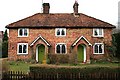
6
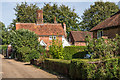
Wyvern Cottage, 15 Milton Street
Wyvern Cottage is a 17th century, timber-framed cottage wholly refaced with red brick, and listed Grade II.
Image: © Hugh Craddock
Taken: 9 Mar 2010
0.13 miles
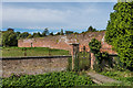
7
Wall, Old Bury Hill Gardens
Former walled garden of Bury Hill. Bury Hill was a large mansion built by James Walter in 1753. In 1805 (or 1812 or 1815, depending on source) the house and a large part of the estate was bought by Robert Barclay, a Southwark Brewer, whose family remained there for almost 150 years.
The house was occupied by the military in the Second World War. After the war it was converted to flats, but whilst this was happening, the centre part was destroyed by fire, although the outer parts survived and remain in residential use.
The gardens of which this the wall, along with the former orangery/stable block in the background, date from the 18th Century and are grade II and grade II* listed respectively - see https://www.historicengland.org.uk/listing/the-list/list-entry/1229032 and https://www.historicengland.org.uk/listing/the-list/list-entry/1228824.
Image: © Ian Capper
Taken: 24 Sep 2016
0.14 miles
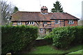
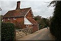
8
Trinity, 12-14 Milton Street
A terrace of three brick built estate cottages, dating from the early C19, two of which have been turned into one dwelling.
Image: © Hugh Craddock
Taken: 9 Mar 2010
0.14 miles
9
Wyvern Cottage
17th Century Cottage in Milton Street. Grade II listed - see https://www.historicengland.org.uk/listing/the-list/list-entry/1279190. On the right is part of 13 - 14 Milton Street, built in the 19th Century and also grade II listed - see
Image: © Ian Capper
Taken: 24 Sep 2016
0.14 miles