IMAGES TAKEN NEAR TO
Westcott Road, DORKING, RH4 3GD
Introduction
This page details the photographs taken nearby to Westcott Road, RH4 3GD by members of the Geograph project.
The Geograph project started in 2005 with the aim of publishing, organising and preserving representative images for every square kilometre of Great Britain, Ireland and the Isle of Man.

There are currently over 7.5m images from over14,400 individuals and you can help contribute to the project by visiting https://www.geograph.org.uk
Image Map
Images are licensed for reuse under creativecommons.org/licenses/by-sa/2.0
Notes
- Clicking on the map will re-center to the selected point.
- The higher the marker number, the further away the image location is from the centre of the postcode.
Image Listing (61 Images Found)
Images are licensed for reuse under creativecommons.org/licenses/by-sa/2.0
Image
Details
Distance
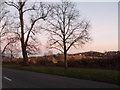
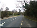
1
A25 Wescott Road
Looking north east along the A25 Wescott Road.
Image: © P Harris
Taken: 11 Aug 2024
0.07 miles
2
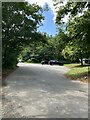
The Nower and Milton Heath car park
The Nower and Milton Heath car park on the A25 Wescott Road.
Image: © P Harris
Taken: 11 Aug 2024
0.09 miles
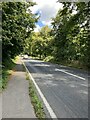
3
A25 Wescott Road
:Looking north east along the A25 Wescott Road.
Image: © P Harris
Taken: 11 Aug 2024
0.13 miles
4
Milton Court Lane
Tree line looking east from Milton Court Lane.
Image: © P Harris
Taken: 11 Aug 2024
0.13 miles
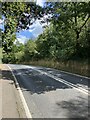
5
Milton Heath
Looking west along the approach road to Bury Hill Fisheries with a turn off to the left to further parking for Milton Heath.
Image: © P Harris
Taken: 11 Aug 2024
0.15 miles
6
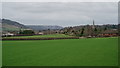
View Towards Dorking
Seen from Miltoncourt Lane. Box Hill is to the extreme left of picture, and Reigate Hill towards the centre of picture.
Image: © Peter Trimming
Taken: 8 Mar 2019
0.16 miles
7
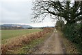
Milton Court Lane (1)
Looking back to Dorking along Milton Court Lane.
Image: © Hugh Craddock
Taken: 7 Feb 2010
0.16 miles
9
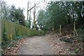
Milton Court Lane (2)
This is the official threshold between Milton Court Lane and bridleway 110. The bridleway is nearer to the photographer, and the road lies beyond the bridleway sign on the right (though there is no material difference between the two). To the right is a private footpath to Milton Heath House, a commercial premises.
Image: © Hugh Craddock
Taken: 7 Feb 2010
0.18 miles