IMAGES TAKEN NEAR TO
Roman Road, DORKING, RH4 3EX
Introduction
This page details the photographs taken nearby to Roman Road, RH4 3EX by members of the Geograph project.
The Geograph project started in 2005 with the aim of publishing, organising and preserving representative images for every square kilometre of Great Britain, Ireland and the Isle of Man.

There are currently over 7.5m images from over14,400 individuals and you can help contribute to the project by visiting https://www.geograph.org.uk
Image Map
Images are licensed for reuse under creativecommons.org/licenses/by-sa/2.0
Notes
- Clicking on the map will re-center to the selected point.
- The higher the marker number, the further away the image location is from the centre of the postcode.
Image Listing (43 Images Found)
Images are licensed for reuse under creativecommons.org/licenses/by-sa/2.0
Image
Details
Distance
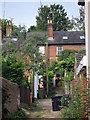
2
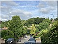
Tower Hill, Dorking
View east from Knoll Road of houses dotted up the slopes of Tower Hill, Dorking.
Image: © P Harris
Taken: 27 Jun 2024
0.08 miles
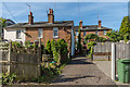
3
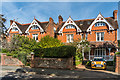
Dorking: Knoll Road
These excellent pan-tiled Edwardian houses are good surviving examples of the type, suitable for a well-to-do family to live in comfort. These are numbered from 2 (far end) to 10, which is actually five houses (No 6 is part of No 8).
Image: © Dr Neil Clifton
Taken: 28 Apr 2015
0.08 miles
4
2 - 10 Knoll Road
1880s villas on Knoll Road, in are area developed on the site of the former Holloway Farm
Image: © Ian Capper
Taken: 24 Sep 2016
0.09 miles
5
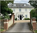
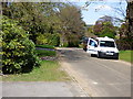
Tower Hill, Dorking
Cleveland House, Tower Hill, Dorking.
Image: © P Harris
Taken: 28 Jun 2024
0.10 miles
6
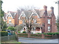
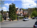
Knoll Road
Substantial brick houses on the corner of Horsham Road, Dorking.
Image: © Colin Smith
Taken: 7 Mar 2009
0.10 miles
7
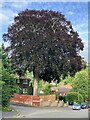
Copper beach tree, Knoll Road
Magnificent copper beach tree on Knoll Road, Dorking.
Image: © P Harris
Taken: 27 Jun 2024
0.11 miles
8
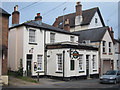
The Bush Inn, Dorking
Pub on Flint Hill Close.
Image: © Oast House Archive
Taken: 6 Aug 2011
0.14 miles
10
Harrow Gate Gardens
Late Victorian cottages, near the site of the "Harrow Gate", the toll gate on the road leading south out of Dorking, now Horsham Road.
Image: © Ian Capper
Taken: 24 Sep 2016
0.14 miles