IMAGES TAKEN NEAR TO
Sondes Farm, Glebe Road, DORKING, RH4 3EF
Introduction
This page details the photographs taken nearby to Sondes Farm, Glebe Road, RH4 3EF by members of the Geograph project.
The Geograph project started in 2005 with the aim of publishing, organising and preserving representative images for every square kilometre of Great Britain, Ireland and the Isle of Man.

There are currently over 7.5m images from over14,400 individuals and you can help contribute to the project by visiting https://www.geograph.org.uk
Image Map
Images are licensed for reuse under creativecommons.org/licenses/by-sa/2.0
Notes
- Clicking on the map will re-center to the selected point.
- The higher the marker number, the further away the image location is from the centre of the postcode.
Image Listing (61 Images Found)
Images are licensed for reuse under creativecommons.org/licenses/by-sa/2.0
Image
Details
Distance
1
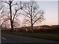
Sondesplace Farm, Dorking, Surrey
Now with other buildings visible in the distance, I can imagine this farm being surrounded by fields only 100 years ago.
Sondes Place is located to the north of the A25, and Sondesplace Farm to the south. Having studied the OS map, I conclude that the A25, which splits these two properties, is on relatively "modern" construction, and that the original road might have run to the south of Milton Heath. I feel another visit coming to, to test this theory.
Image: © Peter Trimming
Taken: 16 Jul 2009
0.05 miles

3
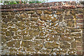
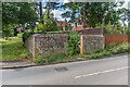
Galleting, Milton Pound
Close up of one of the wall of Milton Pound, situated at the corner of Milton Court Lane and Westcott Road, probably dating from the early 19th Century. Note the galleting between the stones. For wider view, see Image The pound is Grade II listed - see https://historicengland.org.uk/listing/the-list/list-entry/1413953?section=official-listing.
Image: © Ian Capper
Taken: 3 Aug 2021
0.09 miles
4
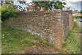
Milton Pound
Pound at the corner of Milton Court Lane and Westcott Road, probably dating from the early 19th Century. Grade II listed - see https://historicengland.org.uk/listing/the-list/list-entry/1413953?section=official-listing.
Image: © Ian Capper
Taken: 3 Aug 2021
0.09 miles
5
Milton Pound
Pound at the corner of Milton Court Lane and Westcott Road, probably dating from the early 19th Century. Grade II listed - see https://historicengland.org.uk/listing/the-list/list-entry/1413953?section=official-listing.
Image: © Ian Capper
Taken: 3 Aug 2021
0.09 miles
6
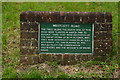
Sign on Westcott Road, Dorking, Surrey
Describing the trees planted, following the Great Storm of October 1987.
Image: © Peter Trimming
Taken: 20 Jul 2012
0.09 miles
7
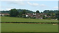
View From Westcott Road, Dorking Surrey
Looking towards Tower Hill.
Image: © Peter Trimming
Taken: 16 Jul 2009
0.10 miles
8
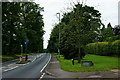
Trees Along Westcott Road, Dorking, Surrey
The younger trees, on the north side of Westcott Road, were planted following the Great Storm of October 1987.
Image: © Peter Trimming
Taken: 20 Jul 2012
0.10 miles
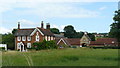
9
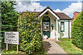
Office, Hanover Court
Estate office at the entrance to Hanover Court, a development of retirement housing off Milton Court Lane, dating from 1989.
Image: © Ian Capper
Taken: 3 Aug 2021
0.12 miles