IMAGES TAKEN NEAR TO
West Bank, DORKING, RH4 3DQ
Introduction
This page details the photographs taken nearby to West Bank, RH4 3DQ by members of the Geograph project.
The Geograph project started in 2005 with the aim of publishing, organising and preserving representative images for every square kilometre of Great Britain, Ireland and the Isle of Man.

There are currently over 7.5m images from over14,400 individuals and you can help contribute to the project by visiting https://www.geograph.org.uk
Image Map
Images are licensed for reuse under creativecommons.org/licenses/by-sa/2.0
Notes
- Clicking on the map will re-center to the selected point.
- The higher the marker number, the further away the image location is from the centre of the postcode.
Image Listing (83 Images Found)
Images are licensed for reuse under creativecommons.org/licenses/by-sa/2.0
Image
Details
Distance
1
West Bank, Dorking
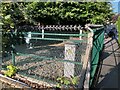
Highly fortified electrical substation enclosure just off West Bank.
Image: © P Harris
Taken: 5 Aug 2024
0.04 miles
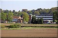
2
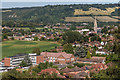
Towards Dorking
Looking towards Dorking from the Lower Greensand ridge of The Nower, with the spire of St Martin's Church on the right. In the foreground is The Priory School and in the background is Box Hill on the North Downs.
Image: © Ian Capper
Taken: 11 Sep 2016
0.05 miles
3
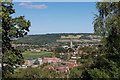
Towards Dorking
Looking towards Dorking from the Lower Greensand ridge of The Nower, with the spire of St Martin's Church right of centre. In the foreground is The Priory School and in the background is Box Hill on the North Downs.
Image: © Ian Capper
Taken: 11 Sep 2016
0.05 miles
4
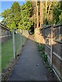
Footpath past The Priory School, Dorking
Footpath past The Priory School, Dorking.
Image: © P Harris
Taken: 5 Aug 2024
0.05 miles
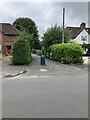
5
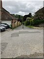
West Bank
Start of a footpath linking the two sections of West Bank in Dorking.
Image: © P Harris
Taken: 16 Jul 2024
0.06 miles
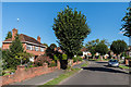
7
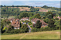
West Bank
Housing in West Bank seen from The Nower. In the background are the North Downs at Denbies.
Image: © Ian Capper
Taken: 11 Sep 2016
0.07 miles
8
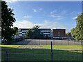
The Priory C of E School, Dorking
Main building - The Priory C of E School, Dorking
Image: © P Harris
Taken: 5 Aug 2024
0.08 miles
9
Longfield Lane
Housing north of The Nower off West Bank (seen in the background). Maps suggest that it was developed in the 1950s or thenabouts.
Image: © Ian Capper
Taken: 11 Sep 2016
0.09 miles
10
Nower Road
Start of a footpath linking Nower Road to West Bank in Dorking.
Image: © P Harris
Taken: 16 Jul 2024
0.09 miles